Pedernales Falls State Park

Trail
20.00 Miles
N/A
$4.00
3point5stars (3.50)10
2stars (2.20)
2point5stars (2.95)
N/A
Yes
Yes
N/A
Johnston City
Blanco
More Info

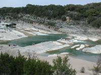
The park gets its name from the large sloping waterfall that cuts through the park.

Getting there: From Austin head west on Highway 290. After near 30 miles turn north on RM 3232. Continue north until 3232 dead ends into a T-section in the road. The entrance to Pedernales Falls State Park is to the right off of FM 2766. The ranger station for paying park entrance fees is a bit less than 3 miles north of the park entrance.

The Hikes: Pedernales Falls is one of the largest and interesting parks to be found in the Central Texas area. With over 5,000 acres it includes a reported 20 miles of trails, scenic views, camping areas and a dramatic waterfall.

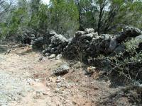
The remains of a homestead and rock fences can be be found along the park's trails.
The land that makes up Pedernales Falls State Park once played host to ranchers and signs of their presence remain in the park to this day. One can find the remains of ranch houses, rock walls and even a settler cemetery.

The park features one of the larger camping areas in central Texas. The primitive camping area can only be accessed by hiking a couple of miles from the Wolf Mountain Trailhead, so you won't find yourself camping next to someone's motor home outfitted with air conditioning and satellite TV.

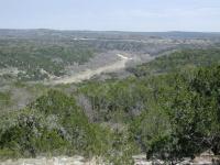
Trails in Pedernales Falls State Park include numerous river and creek valley views.
Most people visit the park for the waterfall that gives the park its name. Large crowds of people may be found walking up and down the shore of the Pedernales River exploring the various rivulets and crannies of the waterfall system.

The trails in the park range from the short Falls Trail to get to Pedernales Falls to the challenging Wolf Mountain Trail that draws many hikers to the park. The 4-Mile Loop trail crosses the Pedernales River to the seldom visited east bank portion of the park and provides some of the best solitude to be found in Central Texas.

Photos
Tree Stump
Even the tree stump was beautiful. (Photo by cadenaang)
Trees along the river
very interesting trees (Photo by jmitchell)
More nice along the river
still no crowds (Photo by jmitchell)
Nice along the river
No crowds (Photo by jmitchell)
Log Entries
Hackenburg Trail
By texasgrape on 1/28/2019
Rating: 3stars Difficulty: 2stars Solitude: 4point5stars
Distance: 1.20 Miles Duration: N/A

This trail is next to the Falls Trails which winds through the trees and base of some cliffs--Very quiet on a cool winter's day--

A Winter's Hike To the Falls
By texasgrape on 12/2/2017
Rating: 3stars Difficulty: 2stars Solitude: 2stars
Distance: 2.00 Miles Duration: N/A

Wife and I took our 9 and 5 year old grandkids on a picnic to the Falls area!  Relaxed on the rocks up river of the falls!  Cool winter's day!

sadly didnt see any painted buntings today
By jimmy peace on 5/14/2015
Rating: 3point5stars Difficulty: 3point5stars Solitude: 4stars
Distance: 3.00 Miles Duration: N/A
Light and Long
By BlairBear on 12/13/2010
Rating: 3stars Difficulty: 2stars Solitude: 3stars
Distance: 5.00 Miles Duration: N/A

My boyfriend and took the afternoon off to spend the afternoon playing in the park. We only did the hike around the falls and the four mile loop. The unmarke braided trails, are a bit confusing, but it's impossible to really get lost and the views are worth it. The four mile loop is a nice flat hike with moderate shade and a few elevation changes make it a nice workout. The trail is wide and had been bladed which isn't a good thing in my opinion, but makes things easier for a large group. Would be good for a picnic. Points of interest: the river crossing at the the beginning of the like (and at the end when you walk back out) and small group of old graves. It looks like there used to be a sign pointing them out, but it's no longer there. You can see the decorative fence surrounding one of the graves from the trail if you're paying attention.

Primitive Hike camp
By loner556 on 1/22/2010
Rating: 3stars Difficulty: 2stars Solitude: 2stars
Distance: 9.00 Miles Duration: N/A

Logged a total of 9 miles in the Wolf Mt. area.  Was out for a 2 night trip.  Hiked in Friday night, day hiked Sat. and hiked out Sunday.

Nowhere near as solitary as it used to be.  10 years ago you might see one or two people out there.   Saturday afternoon day hiking, the front of the primitive area looked like a car camp.  Tents everywhere.

We camped at the very rear and only had one group about 100 yards off so it wasn't too bad.  Still an awesome park to hike.

Beautiful hike
By cadenaang on 2/22/2009
Rating: 3stars Difficulty: 1star Solitude: 3stars
Distance: 5.00 Miles Duration: N/A

We went off the official trail, where countless others had gone before and just followed the river.  The river was low and the falls were less than spectacular, but it was still serene, beautiful and peaceful.  At the trammel crossing we ran across other hiker otherwise the solitude was great!

Always a beautiful hike
By jmitchell on 11/14/2007
Rating: 3stars Difficulty: 2stars Solitude: 2stars
Distance: 5.00 Miles Duration: 2 hours

Blazed a trail along the river to get away from the crowds

It was a very enjoyable trip.
By twnajera on 4/2/2007
Rating: 4stars Difficulty: 2stars Solitude: 1star
Distance: 2.00 Miles Duration: 4 minutes
I brought my Lab, Tido, to the falls and we spent most of the day just lookin around. He very much enjoyed it, he did have a little trouble running on the rocks cause he twisted his ankle twice but he's only a puppy.
By Riff Raff on 5/20/2006
Rating: 4point5stars Difficulty: 3point5stars Solitude: 3stars
Distance: 0.01 Mile Duration: N/A
Horse Trails, South Loop from Bird Blind
By nobody on 6/4/2005
Rating: 5stars Difficulty: 2stars Solitude: 5stars
Distance: 11.00 Miles Duration: N/A
In addition to the designated hiking trails, there are at least 12 miles of equestrial trails not included on the normal park map. If you ask real nicely the folks at the headquarters will give you a very cheesy map of them. Photocopy of the normal map with the horse trails filled in with a felt tip marker.

Starting from the birding blind (just outside the horse corral area) I went through the corral area and got on the trail where the sign marks "Gunney's Horse Trail". Everywhere else this trail is labelled as the South Loop and the Short Loop. It's a long narrow loop trail with a cutoff in the middle that forms the Short Trail. Unlike the Wolf Mountain trail, the equestrian trails are generally unimproved, though they sometimes follow Jeep tracks. No asphalt or other nastiness.

Starting out, the trail was very muddy (it rained the day before) but after 1/2 a mile or so things dried out and got better. It stayed that way until the last half mile or so of the return trip. The last 4 or 5 miles are spent walking next to the park boundary, which is marked by an 8 foot tall fence. This wasn't as unpleasant as it sounds, but it wasn't nearly as nice as the much more pristine terrain that the rest of the trail followed. A little ways before encountering the fence the trail crosses the park road just inside the front gate. It might be worth setting up a car shuttle to avoid the fence walking, especially if you aren't really interested in the full 11 mile round trip.

I've now hike the full length once and the portion starting at the Wolf Mountain trailhead (~7 mile loop) and not seen anyone else on the trail. That includes a visit on Memorial Day weekend when there was a line 6 cars long to get an entrance permit and the park was pretty much full up. They don't advertise this trail and the solitude is wonderful.
Recommended Item
Recommended Item Official Guide to Texas State Parks and Historic Sites: New Edition
Laurence Parent
List Price: $27.95 Your price: $24.27 Buy Now
Since it was first published in 1996, Official Guide to Texas State Parks and Historic Sites has become Texans’ one-stop source for information on great places to camp, fish, hike, backpack, swim, ride horseback, go rock climbing, view scenic landscapes, tour historical sites, and enjoy almost any other outdoor recreation.