Getting there: From Dallas head north on Highway 75 through Denison. Take exit 72
and head north on Highway 91 to FM 1310. Head west on FM1310 for 1.8 miles to the entrance to
the park. Take the right fork in the road off of Park Road 20 and look for a very small parking
area on the right side of the road opposite the trailhead soon after the residence on the left
side of the road.
The Hikes: According to the 2002 Texas Parks and Wildlife Department Land and
Water Resources Conservation Plan, Eisenhower State Park was the most visited Texas state park. I had
been informed by someone who had visited the park in the past that there were no trails at the
park, something that might be expected of a busy park that caters mostly to boaters and RV
campers, which this one does. However, the official park website was adamant that approximately
four miles of trails existed. So we had to see for ourselves.
-small.jpg)
The trailhead is somewhat tough to locate. Note the gate indicating pedestrians only. No bikes allowed on this portion of the trail.
It's easy to see why someone may think that there are no trails at the park. It's fairly difficult to find a trailhead! The official park maps shows trails that cross the main park roadway several times, but it does not identify a specific starting point for the trail. We ended up driving around a few camp sites looking for clues before we happened upon a trailhead and parking area, with enough space for two cars.
The hike started at the waypoint "Trailhead". About a half mile of trail is designated hiking
only and at the trailhead there is a small hinged wooden gate that gets that point across. This
section of the trail also includes the intrepretive trail that the park advertises.
Unfortunately, the park was out of interpretive trail guides on our visit, so at best we can
report that indeed most of the guide markers are in place. However, some are in need of some
attention.
-small.jpg)
Some creek crossings are made simple through bridges such as this one. Most others will rarely run with water except after rains.
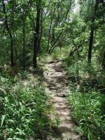
One gets an immediate sense of what the trail will be like. Contrary to what we were expecting
the trail tends to be somewhat overgrown and in some places rocky. What we expected, based on
no real information other than the park map, was a somewhat more timid trail that connected
separate camping areas, such as can be found the Onion Creek Trail at
McKinney Falls State Park.
The revelation meant having to work a bit more to complete the trail than we originally intended
to do. There is a positive side to the trail's roughness though. After 3 miles on the trail
we saw only two other people on the trail and only a handful of folks off the trail in camp sites. Despite passing near numerous camping areas of the park, the trail somehow retains some sense of solitude, if one can ignore the motor boats in the lake and the cars at the numerous road crossings.
-small.jpg)
Much of the trail was overgrown on our visit, which made the going a bit slower than anticipated.
As the trail comes up to the first road crossing the interpretive trail portion of the hike is
over. A matching swinging gate marks the end point of the hiking-only portion of the trail.
After crossing the road the trail gains elevation slightly on a ridge overlooking the road below
and then parallels it for a distance. Although only slightly rougher than the interpretive
section, the trail from this point onward will seem a bit more overgrown and the creek crossings
somewhat more difficult.
No creek crossing on the hike requires getting wet, but some of the crossings do require venturing slightly off the official trail to find a suitable spot to traverse the stream.
Typically, this was no more than about 10-20 feet uphill over a path that had obviously been
blazed by several visitors in the past.
-small.jpg)
Most of the shoreline of the lake consists of large boulders like those seen here.
After crossing the Bois D'Arc camping area road the trail enters what the park refers to as
Cedar Hollow. Aptly named, this section of the hike is densely wooded and includes an abundance
of Cedar in addition to some of the other varieties of trees found in the park, such as Oak,
Cottonwood and Elm. The heavy rains that preceeded our visit were still apparent as the air
felt thicker and wetter here than in other parts of the hike.
After bottoming out at the last creek crossing in Cedar Hollow the trail gains elevation to the top of a ridge on what the park refers to as Deer Haven. Unfortunately, on our trip we did not
encounter any deer. However we were treated to an unusually large number of Cardinals flying
through the canopy before topping out on the Deer Haven ridge.

This small pier provides visitors a chance to get down to water level.
The trail again descends towards the lake shore into what the park refers to as Fossil Ridge.
Although one can find evidence of it throughout the park, this section of the hike does produce
an extraordinary abundance of sea shell fossils cemented together to form a rough aggregated
rock. Just as man had changed the landscape with the creation of Lake Texoma in 1944, so too did nature, when this section of the Earth was under water millions of years ago. Most of the fossils to be found here are small. For an example of how large some of the crustaceans could get, stop by the ranger station at the park entrance and look through the garden along the side of the building.
To our surprise the trail at Eisenhower State Park was a bit more challenging than we suspected.
A fishing pier sits near the waypoint "Pier". Due to the heavy foliage and rocky terrain there
are not too many spots from which to get wide open views of the lake. This pier provides one of
them.
A short distance north of the pier is an ideal spot for enjoying lunch or just resting. Numerous picnic tables are situated in the shade and one of them provides great views of the lake. The picnic tables do not sit next to any camping spot and we saw no one in the area when we passed by, so they may provide a quiet spot at which to rest and refuel.
The trail continues to follow the lake shore northward until it comes to land's end. At least
it's the end of land for this small peninsula. The trail dead ends on a point of rock that
overhangs the lake below. It's a dramatic sight would provide a fitting point at which to turn
back, if you intended to double back on the trail.
-small.jpg)
There are not too many sections of the trail that open up to the lake. Here is one of them.
Since we did not intend to double up on the trail we pulled back from the point and headed to
our right, towards the south to follow the trail to its end. A small beach area sits in a narrow cove at the tip of the peninsula. At the waypoint "Straight" go straight ahead to continue the hike or take a right turn here to cool off in Lake Texoma.
There remains only about a half mile of trail left that mostly parallels the overflow camping
area just uphill. After crossing the road twice more the trail dead ends at the Fossil Ridge
Camping area road.
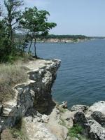
The end of the line. The trail dead ends at this point over the lake.
Due to time constraints and not wanting to double up on our chiggers on the way back to the
trailhead we decided to try our luck at hiking along Park Road 20 back to the car. Let's just
say that this is not too advisable, particularly if you are hiking with children. There is at
best a small shoulder along the road and at worst no shoulder at all. It's not a particulary
pedestrian friendly road. However, we made it back to the car in about a third the time it
would have taken us to double back on the trail.
Our one way hike along the trail totalled 3.5 miles and was accomplished in about 3 hours, with a stop for lunch. Double the distance and time values if you elect to completely double back on
the trail to the trailhead. The hike summary above shows the full out and back distance that
is possible.
We were pleasantly surprised that the trail was more challenging than expected. Perhaps due to
recent rains, the trail was largely overgrown. Again, this was somewhat of a surprise. Since
Eisenhower State Park is one of the state's busiest parks this trail would make an excellent "trail adoption" project for some hiking or scouting group in the area.