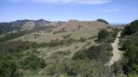
A look at some of the ridge high points in Sibley.
Though it may not be completely obvious at first glance, hikers at Sibley Volcanic Preserve have the opportunity to walk right into a volcano. Timing is everything and the fact that the volcanoes here have been dormant for about 10 million years makes the excursion interesting, but not terribly dangerous.
This preserve was one of the first parks added to the East Bay Regional Parks District portfolio. It was originally named Round Top Park, after the park's signature highpoint.
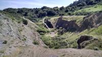
Looking down into an old quarry pit, and a volcano.
The park's trails can be divided up into at least three distinct sections. The lowest elevation in the park marks the route of the Bay Area Ridge Trail trail as it passes through Sibley. This 350 mile trail is a work in progress that will eventually encircle the San Francisco Bay area from the high points overlooking the bay. Because the trail here parallels Round Top Creek there's a greater chance of encountering muddy paths and a creek crossing or two.
The middle elevation trails leading out to the Pond at the northern area of the park are less crowded than the higher trails. The scenery here is not quite as interesting and the trails near the pond can get a lot of traffic noise from the stream of cars going into the nearby Caldecott Tunnel.
Walking into an old quarry pit.
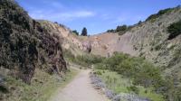
The real draw of the park are the volcanic formations and high points, which one gets by sticking to the higher trails. The Round Top Loop and Volcanic Trails are the paths of choice here. Inside trail maps available at the park's trailhead there is an interpretive guide that provides facts about the park's geological features. Is the small valley you just hiked into a quarry, a volcanic feature, or both? The guide will let you know.
Originally the parks namesake, Round Top is the highest point "in" the park. The peak is used for utilities and radio towers and thus off limits to park visitors but the Round Top Loop encircles it. There's great variety in vegetation as you circumnavigate Round Top with some areas more Sun exposed with scrubby vegetation and others fully enclosed by tall stands of pine trees.
The Volcanic Trail contains most of the interpretive guide stations. A couple of high points with well used, though unofficial, paths leading to their summits provide some breathtaking views of San Francisco and the surrounding Bay Area.
Labyrinthian is a word that can be used to describe Sibley and it's not because its trails are arranged in a confusing maze. Rather, the term is apt because of the numerous labyrinths that have been set up at several points along the trails. A couple are situated right in the center of the old quarry pits. The steep rock walls around them create a dramatic scene.