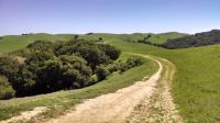
A view of the Briones Crest Trail as is undulates along a ridge towards Briones Peak.
At 6,255 acres, Briones Regional Park is one of the largest parks in the
East Bay Regional Park District system. The name derives from the Briones family, who claimed title to the land and started ranching here when California was still part of Mexico in the early 1800's.
The terrain is hilly and occasionally very steep. Briones Peak tops out the park at 1,483 feet in elevation. The terrain mostly consists of rolling grasslands though there are clusters of trees in the sheltered valleys. Be sure to bring some sunblock as the majority of the time you'll be fully exposed to direct sunlight.

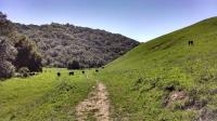
They still run cattle on the land and you're likely to see some on the trail. Here are a few along Valley Trail.
With a park this size, it's difficult to specify a level of difficulty for hiking there. It really depends on which trails you hike and how long you stay out. The official park map shows a couple of trails that require less effort by marking them in red. From the main parking area, the Old Briones Trail Road and Valley Trail follow a gentle stream into a valley lined by steep slopes. With scant elevation gain, it's a route that's easily handled by small kids. It's a common foraging area for the parks most common resident though, cows.
EBMUD also provides accessibility reports for some of the easier trails including Abrigo Valley Trail, Alhambra Trail and Old Briones Road Trail.
Portions of the park continue to be used for cattle ranching with leases on sections of the land through the 2060's. There may be some gates to go through as the trail passes from one pasture to another. The presence of cattle means you might have to keep one eye on the beautiful scenery and one eye on the trail right in front of you to ensure that you don't step on a cow patty. The quantity of bovine land mines that you'll encounter vary from segment to segment, but it can get pretty commonplace in some areas.