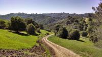
A view of the Rim Trail as it descends and quickly ascents along the crown surrounding the reservoir. You can see the trail ascending to the right and then following the ridge all of the way to the left peak.
Lafayette Reservoir is a water source maintained by the East Bay Municipal Utility District. Impounding water for more reliable service is the main goal of the facility, but like in many cases the land surrounding the body of water serves as a natural area for outdoor recreation.
The park's trails consist of two concentric circular trails that surround the lake. An inner paved hike and bike trail and a rougher, higher Rim Trail. The two trails are joined together by several spoke-like connector trails,
One might be led to conclude that a lake trail close to the water would be relatively flat and easy. Such is not the case! Though not a tough trail, the paved hike and bike trail is undulating with a few short steep sections. It also spends relatively little of its approximate 2.7 mile length on the shoreline of the lake. A thick curtain of trees and shrubs block the view of the lake most of the time.
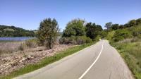
The paved trail around the lake surprisingly doesn't have a lot of lake views.
The inner loop is the most popular trail in the park, frequented by picnickers, exercise walkers and families with children. The area around the playground was particularly packed.
Fishing is allowed in the lake and visitors can also rent boats. Swimming and wading into the water is not allowed. Strangely, the park rules also prohibit "contact" with the water. The wording seems to suggest that too much contact with the water would compromise the integrity of the water supply. Surely the presence of thousands of fish, amphibians and other animals in the water would have a far greater effect on water quality than a few hikers sticking their hands in the water to cool off.
The Rim Trail forms most of a circle around the inner trail and lake and runs for about 4.7 miles. It follows the high point ridge line near the perimeter of the recreation area's boundary. This hard pack dirt trail has numerous steep ascents and descents of as steep a pitch as you'll find anywhere.
The steepness of some portions of the trail has a price associated with it. Deeps ruts on the packed dirt surface are being cut by rainwater runoff that speeds down the slopes unobstructed by vegetation or looser soil to soak up the moisture. Switchbacks are a typical solution to problems such as these, but they are not employed here.
Despite the steepness of the terrain, the Rim Trail is surprisingly well used. The sight of people wheezing and gasping for air after ascending a particularly steep segment of trail doesn't seem to have kept many people away.