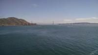
A view of the Golden Gate Bridge and San Francisco with the Marin Headlands on the left.
The Marin Headleads are perhaps best known as the picturesque backdrop for countless photos taken of the Golden Gate Bridge. What many don't realize is that the hilly terrain just north of San Francisco was once brimming with advanced weaponry, positioned to defend the entrance to one of the most important harbors on America's West Coast. Thankfully, today the area is packed with miles of hiking trails.
Much of the hilly terrain in the Marin Headlands is wind-swept grassland. That provides for ample panoramic views across land and ocean, but also necessitates sunblock on sunny days.
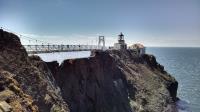
The Point Bonita Lighthouse with suspension bridge that provides access over the knife ridge joining it to the rest of the peninsula.
The southwest corner of the Headlands features a few short paths highlighted by the Point Bonita Lighthouse Trail. From the parking area closest to the trailhead the path is paved. This makes navigation mostly easy if one ignores one short steep pitch and a somewhat rough surface when going through a tunnel on the way to the lighthouse.
The longest bridge on the trail crosses over a narrow ridge line to get to the lighthouse. The cable suspension bridge can sway quite a bit with large numbers of people crossing over. There is no access to the lighthouse's Fresnel lens, though it can be clearly seen through the glass of the top of the lighthouse. Unlike some lighthouses, the lightsource sits only about a story above its base. Any additional height would have placed the light above the common fog layer height, making it harder for ships to see.
The Rodeo Beach Trail is a sometimes sandy path that leads to the southern portion of the Rodeo Beach. The northern half is adjacent to Fort Cronkhite and is a popular spot for visitors. The southern half here, separated for the most part by a steep rock wall pounded by waves, is far less crowded.
The headlands are just one parcel of the widespread Golden Gate National Recreation Area. The GGNRA consists of scattered parks that stretch from Santa Clara in the south all the way to Marin County in the north.