Trione-Annadel State Park

Trail
40.00 Miles
N/A
$7.00
3stars (3.00)4
3stars (3.00)
2point5stars (2.75)
N/A
Yes
No
No
Santa Rosa
Sonoma
More Info

Location

Trione-Annadel State Park is located in central Sonoma County, just east of the county seat of Santa Rosa. At over 5,500 acres, it sits near the northern end of the world famous wine growing area of Sonoma Valley. The land slopes downward towards the north from the Bennett Mountain peak in the Sonoma Mountains. The main entrance to the park is typically reached by turning onto Los Alamos off of Highway 12.

History

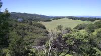
A view from the Warren Richardson Trail looking over the varied terrain at Trione-Annadel.
The Southern Pomo Indians lived in the area and the park was an important source for obsidian rock which could be used to make knives and arrow points. When hiking on some of the trails keep an eye open for the black shiny flecks of obsidian that sparkle like broken glass.

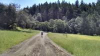
Coppertone leads the way towards Lake Ilsanjo.
The park eventually became part of the 19,000 acre Los Guilicos Rancho in the 1830's as cattle ranching and farming became more common. I addition to obsidian, the rocky slopes also yielded material used for cobblestones used to build San Francisco and Sacramento. Some of the remnants of those quarries can be seen today. The state of California acquired the property in 1971 and it became a park in 1974.

Trione-Annadel was and is the site of some aggressive forest management designed to maintain the historic oak woodlands nature of the area. Over the years many Douglas Fir trees have moved into the area, taking advantage of the lack of periodic fire that would naturally curtail their propagation. CalFire has "girdled" a number of the Firs to kill them off, which explains the strangely large number of dead trees or snags one can still find around the park.

Until 2016, the park was known as Annadel State Park. Following some research about the park's founding the Santa Rosa City Council successfully petitioned to have Henry Trione's name added to the park's moniker given his extensive efforts to make the park a reality. Many locals continue to refer to the park as simply Annadel and even the park's official brochures continue to sport the shorter name.

The Trails

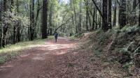
A segment of the Rough Go Trail at Trione-Annadel.
Despite having some nice hiking trails the most common visitor to Trione-Annadel seems to be mountain bikers. As one typically finds elsewhere, the vast majority and cyclists and hikers are courteous to one another and there are few issues. But given the differing speeds with which each group traverses the terrain it's important to be on your guard and ready to move to one side of the trail or the other.

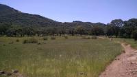
A view of False Lake Meadow from the trail.
Steve's "S" Trail near the main trailhead is the sole hikers only trail in the park and one of the more enjoyable segments. The tree cover here is complete with Douglas Firs and California Bay Trees overhead and ferns below. The trail is also a prime location to spot glassy obsidian on the trail.

The park extends to the north from the peak of Bennett Mountain. Though there are some steep pitches to be found here and there (such as on the aptly named Rough-Go Trail), much of the terrain consists of gently rolling slopes of moderate difficulty.

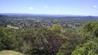
A view of Santa Rosa from Wymore Quarry.
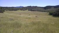
Tree cover is mixed with some fully shaded and cool stands of trees interspersed with open, sunny and warmer grassy meadows. Among the trees to be found in the park are numerous varieties of Oaks, Big Leaf Maple, California Bay, Redwood and Douglas Fir.

Just as tree cover can vary greatly from segment to segment, so can the surface of the trail. For example, the Two Quarry Trail is very rocky. The South Burma Trail, which parallels it just a bit uphill has a surface that consists of largely packed dirt and is often dusty with a few boulders sprinkled about.

Coppertone walks on one of the many shaded trails in the park.
Trail junctions are well marked with wooden posts indicating what each segment is named and the number of rogue trails is thankfully small. With a fine trail map available at the main entrance gate there is little chance you'd get lost in Trione-Annadel.

A few spots in the park provide fantastic views into or out of the park. The site of the Wymore Quarry along Cobblestone Trail looks out over the growing expanse of Santa Rosa. The main fire road thoroughfare of the Warren Richardson Trail has a spot that provides a wide view over the park including Lake Ilsanjo and False Lake Meadow.

Lake Insanjo lies at the heart of the park and is the natural destination for many visitors. Numerous picnic benches around the perimeter of the lake provide spots for a meal or a snack before heading back out.

Photos
Turkeys
Some of the many turkeys we saw on the trail in the park. (Photo by Austin Explorer)
North Burma Trail
Coppertone ascends the northern segment of the North Burma Trail. (Photo by Austin Explorer)
Trail View
Lawndale Trail is sometimes quite rocky and uneven. This segment was not too bad. (Photo by Austin Explorer)
Sonoma Valley
Looking across Sonoma Valley from Lawndale Trail. (Photo by Austin Explorer)
Lake Ilsanjo
Looking over the park from Warren Richardson Trail. Lake Ilsanjo can be seen to the left in the distance. (Photo by Austin Explorer)
Marsh Trail
The Marsh Trail skirts along the edge of Buick Meadow. (Photo by Austin Explorer)
Meadow
Several meadows open up the sky within the park. (Photo by Austin Explorer)
Hood Mountain
Hood Mountain in a nearby regional park as seen from Annadel State Park. (Photo by Austin Explorer)
Steves' S Trail
Unlike most trails at Annadel, Steves' S Trail only allows hikers. It was the most quiet we'd experienced all day. (Photo by Austin Explorer)
Lightshow
Hiking along the Live Oak Trail. The Sun shining through the clouds was projecting interesting patterns of light and shadow on the hills in the distance. (Photo by Austin Explorer)
Coppertone
Coppertone and probably the Orchard Trail. (Photo by Austin Explorer)
Waste Rock
Left over rock from the Wymore Quarry. (Photo by Austin Explorer)

Only showing last 12 photos. View All Photos

Log Entries
Mapping out unhiked trail segments
By Austin Explorer on 12/24/2022
Rating: 3stars Difficulty: 3stars Solitude: 2stars
Distance: 4.39 Miles Duration: 2 hours, 43 minutes

Coppertone and I wanted to get some hiking in before the expected rains made trails too muddy.  Trione-Annadel was our target due to some trail segments we noticed that needed to be mapped.

We started off walking west along Channel Trail.  This parallels Channel Drive, which we used to drive back to our trailhead.  Close proximity to the road normally means a less enjoyable experience.  However, in this case, it's not so bad.  There were but a few cars that drove by and those that did passed at a slow speed.  There were far more walkers and cyclists than drivers on the pavement.

On the proper trails there were many more cyclists than hikers.  So it's important to be alert for any fast moving surprises around a turn.  We encountered no problems on that day.

We found the trails to be moist but not enough to make them muddy.  Perfect.

We passed by a couple of rafters of turkeys.  One all male the other all female.  All added up to about 18 individuals.  Neither group seemed too spooked by humans whether on foot or on a bike.

We turned left onto North Burma Trail since we had not yet mapped the northern segment of this trail.  This section turned out to be my favorite of the day.  Our turnaround point was the junction with Live Oak Trail.  At this point we doubled back to Channel Trail and then turned west.

Channel Trail ends at the main park HQ.  Instead of doubling back on the trail we just hiked we opted to walk along Channel Drive, like many other walkers.  Along this path we searched for several geocaches, logging three of them.

Mapping the east side
By Austin Explorer on 8/6/2022
Rating: 3stars Difficulty: 3stars Solitude: 3stars
Distance: 3.56 Miles Duration: 2 hours, 12 minutes

Coppertone and I made our first foray into Trione-Annadel from the trailhead along Lawndale Road.  We started off hiking along the aptly named Lawndale Trail as it climbed and twisted deeper into the park.

It was a bit warmer than we were expecting and the Sun was a bit oppresive.  But the frequent patches of Oak trees provided some much needed relief.

We saw more cyclists than hikers out today, some of whom had some issues with the sometimes very rocky and uneven terrain.

The heat may have contributed to the blister Coppertone developed that caused us to cut our day short.  We optioned take another trail back to complete a balloon route.  Turns out the path, though well worn in places is unofficial.  On top of that it also hosts a hefty amount of poison oak.  So I won't bother including that trail segment in my track file.  Just stick with the official trails.  It's easier to follow and the views are better there as well.

When driving out we checked out the trailhead at Shultz Road at the southeast corner of the park.  A narrow one lane road with no shoulder and no parking seems to make that trailhead for locals only.

Two Quarry - South Burma Trail Loop
By Austin Explorer on 5/29/2017
Rating: 3stars Difficulty: 3stars Solitude: 3stars
Distance: 8.86 Miles Duration: 4 hours, 49 minutes

Coppertone and I returned for follow up visit to map some trails that we had not been able to hike and map last year.  Even after today's outing I estimate we'd have to come back at least twice more before we hike all of the trails.

Every time we come to Annadel it seems to be hot, and today was no exception. We began at the main trailhead and using Warren Richardson Trail as the starting off point made an 8+ mile loop out of Two Quarry Trail and South Burma Trail.

Turkey calls could be heard off in the distance.  We were surprised to see a solitary turkey in the brush just 10 feet from the trail foraging for food and fairly unconcerned with our presense.

We stopped for a snack on a picnic bench along South Burma Trail and as we were packing up to hike some more we noticed a good number of plastic army men lodged into nooks and crannies of the Douglas Fir tree truck adjacent to the park bench.  They continued a good 15 feet up.

Coppertone amused herself by starting small rock cairns on top of the large rocks adjacent to or right in the middle of the trails.  This was fun for a while until it became obvious that that there were so many that could be "decorated".

Better than expected
By Austin Explorer on 5/1/2016
Rating: 3stars Difficulty: 3stars Solitude: 3stars
Distance: 10.20 Miles Duration: 4 hours, 51 minutes

Coppertone and I were not entirely sure what to expect from Annadel given its close proximity to Santa Rosa.  We thought it might be more of an urban park with lots of trails and little nature.  It turns out there's plenty of acreage here to spread people out enough such that we found some quiet moments of solitude and nice views of the surrounding terrain.

Driving into the park made us think we had made a mistake.  The number of people walking and riding on Channel Drive into the park was pretty large.  The one lane road leading to the horse trailer parking where we started out made passing people and cyclists going two abreast a little nerve wracking.  Then, once we started off on the main fire road from the trailhead it seemed walkers were outnumbered by cyclists by 20 to 1.  What had we gotten ourselves into?

With distance from the trailhead and once we'd gotten off of the fire road things calmed down a lot.  We were treated to gently rolling hills that provided scenic vistas in places without the pain of steep sections found elsewhere in Sonoma Valley.

We tried to make a couple of loops and keep our trail duplication to a minimum, which came to a total of 10.2 miles.  I'd say we're only about a quarter done with the trails in the park.

Recommended Item
Recommended Item 101 Hikes in Northern California: Exploring Mountains, Valley, and Seashore
Matt Heid
List Price: $17.95 Your price: $4.99 Buy Now
101 Hikes in Northern California encompasses the full spectrum of the region’s incredible natural diversity—the jagged granite of the High Sierra, crashing surf of the Pacific Coast, magnificent redwoods of the North Coast, spectacular views of the Bay Area, and much more. All trips have been thoroughly updated for the second edition, and 26 trips have been significantly expanded or reworked. Each hike description includes an easy-to-use header outlining the trip basics, driving directions, an in-depth trail description, up-to-date map, and the locations of the nearest visitor center and campground.