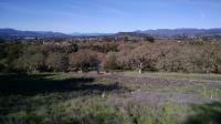
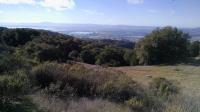
Looking back from the Buckeye Trail towards the trailhead offers one of the first vista views from the park.
Situated in the southeastern corner of Napa County, Skyline Wilderness Park consists of 850 acres with about 25 miles of trails. Seems like a nice public park, no? But contrary to what it appears, Skyline Wilderness Park is not a government owned park at all. No city, county, state or federal entity is ultimately responsible for its maintenance. How is this possible?
In 1979, the state of California was dialing back funding of state hospitals and the large swaths of land surrounding them were eyed for sale or redevelopment. Napa County entered into a 50 year lease for the Napa State Hospital land that now encompasses most of Skyline Park for the princely sum of $100 per year. The county in turn leases the property to the Skyline Park Citizens Council, who actually handle all of the day to day operations. A few part-time employees and a lot of volunteers do all of the work to maintain this park for the public.
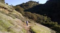
Coppertone ascending a steep section of the Chaparral Trail.
Plans have been hatched in the past to finalize a sale of the land to the county to ensure it does not get sold by the state to developers or the nearby quarry mining operation. Each of these efforts has so far failed to reach an agreement.
Most of the trails at Skyline are multi-use, which can mean encountering both cyclists and horses. For single track trails this can make passing by each other a bit of a delicate procedure, but the trail users here seem to be fairly considerate of one another.
The park can be broken in three sections, each of which provide their own set of pluses and minuses, depending upon the desire of the visitor. The flatter Lake Marie Creek corridor down the middle of the park provides the easiest outing for those not looking for much of a challenge. The Sugarloaf Mountain area in the northern section of the park provides steep terrain and great views of Napa Valley. The eponymous Skyline Trail in the southern section of the trail splits the difference in terms of difficulty.
Lake Marie Creek Corridor
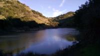
Lake Marie, where we got onto Lake Marie Road for the quickest route back to the trailhead.
The park generally starts near Lake Camille and flows back into the canyon surrounding Marie Creek. To the south of the park lies an extensive quarry operation, but you'd never know it given the lay of the land. Once you get away from the park entrance area the park very much exudes a wilderness experience.
But to the get to the wilderness one does need to run something of a gauntlet soon after the parking and picnic area. The trail bisecting Lake Louise and Lake Camille is hemmed in on either side by a chain link fence. Cattle being herded is an image that comes to mind. By the time one gets to the junction with Lake Marie Road and the River-to-Ridge Trail everything changes and the real hiking can begin.
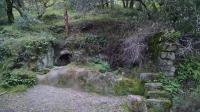
Some interesting ruins on the side of the trail. Appears to have been a shelter cut into the rock, featuring a wood stove in the back.
Lake Marie Road is a wide dirt road trail that follows the path of Lake Marie Creek and so provides the easiest path deep into the small canyon, leading all the way to Lake Marie. It's also where you're likely to find the most part visitors.
At the intersection of Lake Marie Road and Bayleaf Trail the official park map marks the existence of a fig tree. What's so special about a fig tree? Well, it's big. Really big. During the winter the lack of leaves might not provide much of a hint about the true scope of the tree. It's worth a stop at the northeast corner of the trail intersection here.
Lake Marie was constructed in 1908 to ensure a reliable water supply for the hospital. Today it serves as a common turnaround point for many park visitors and a resting and feeding spot for ducks and other bird life.
Sugarloaf Mountain
Looking west onto southern Napa and Sonoma counties. Marin County and San Pablo Bay can be see to the left in the distance.
The highpoint of the park is not to be confused with
Sugarloaf Ridge State Park in nearby Sonoma County. At 1,630 feet above sea level the peak does not impress by Rocky Mountain standards, but the steep trails leading to its apex impresses the hiker enough with the effort required to reach the top.
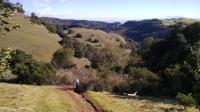
From the main park trailhead, the aptly named Manzanita Trail heads east then south. Even before any serious elevation gains are inflicted on the visitor there are some decent views back into the park and beyond. Thatcher Rimrock Trail is when the climbing begins in earnest and it's on this northern side of the mountain that one will be rewarded with the best views into Napa Valley.
Coppertone descends down the steep backside of Sugarloaf Peak.
The Sugarloaf Mountain peak itself is a bit of a letdown after the views on the way up given the dense tree cover preventing much of a view from the top. Near the backside top of the mountain one is also faced with a short, but very steep pitch of trail. After that travail though there are plenty of canyon views to be enjoyed. Though the vistas may not be as wide ranging as those on the northern side, they are quieter and more peaceful lending few signs of civilization.
Skyline Trail
The Skyline Trail here in the park is part of the expansive and expanding Bay Area Ridge Trail.
The trail continues along the southern shore of Lake Marie then continues above the creek to the back boundary of the park. Here an easement has been secured, allowing the hiker to continue onto a section of trail on private property known as the Tuteur Loop.
Martha Walker Native Habitat Garden
Skyline Park boasts of more features that just wilderness trails. Not far from the main parking and picnic areas a fenced in garden area complete with walking paths and markers provides a short strolling opportunity through a verdant landscape. The Napa Chapter of the California Native Plant Society is responsible for the 3 acre plot that highlights the importance of beauty of native plants.