Bothe-Napa Valley State Park

Trail
10.00 Miles
N/A
N/A
3stars (3.00)3
3stars (3.00)
2point5stars (2.67)
N/A
Yes
No
N/A
Calistoga
Napa
More Info

Location And Access

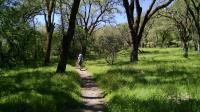
Coppertone hikes the History Trail between the pioneer cemetery and the Bale Grist Mill.
Nestled along the eastern slope of the Mayacamas Mountains, Bothe-Napa Valley State Park sits on 1,900 acres five miles north of St. Helena. The park entrance signs can be seen directly from Highway 29/128 that runs along the length of Napa Valley.

Though a state park, maintenance and administration of the park is provided by the Napa County Regional Park and Open Space District. Your state parks pass will get you into the park but be aware that the money spent on the pass does not directly benefit the group actually responsible for the day-to-day operations of this park. There is a $6.00 entrance fee to use the park (May 2017).

History

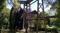
The Bale Grist Mill has been restored into full working order, including its large water wheel.
Edward Bale married into the influential Vallejo family and received a Mexican land grant of 18,000 acres in the 1841. His colorful history included a few brushes with the law but also contained a few industrious endeavours, such as the construction of his grist mill that stands to this day. Adjacent to and nearly enclosed by the park is the Bale Grist Mill State Historic Park. The mill machinery is completely operational and visitors can watch grains being ground into a fine powder and even purchase some of the output from the mill.

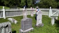
The Tucker and Kellogg families were well represented in the small pioneer cemetery.
It took some investigation into why the name "Bothe" is attached to the park. Nothing in the park's brochure mentions it. Reinhold and Jeanne Bothe owned the land that would become Napa Valley State Park and were proprietors of Paradise Park starting in 1929. The resort featured forty one cabins, a spring-fed swimming pool, stables, a lounge, tennis and bocce ball courts and a large, well-stocked bar. For some time there was even a small airfield just across the road for visitors to fly in!

The resort, which started out as a fairly luxurious outfit, waxed and waned with the fortunes of fate, a World War and changing clientele. The property seems to have been sold and resold a couple of times. In the 1950's the resort catered more towards families in cars and day hikers than high flying celebrities. California Parks purchased the property from the Bothe family in 1960. Of the park's old structures, only the spring fed pool remains and is used today.

The Trails

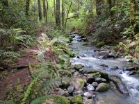
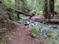
At times Redwood Trail gets really close to the creek.
There are about 10 miles of trails available in the park with several out and backs and loops possible. Generally, the park and its trails originate near Highway 29 and head uphill from that point into the canyon carved by Ritchey Creek.

The History Trail out and back is 1.1 miles in length one way and passes by not only the pioneer cemetery near the parking area but also leads to the Bale Grist Mill mentioned earlier. The trail parallels Highway 29 but moves far enough away to avoid much of the road noise. In some respects the trail here is more difficult than some of the others leading deeper into the park along Ritchey Creek. A little bit of elevation gain and some rocky surface adds some difficulty to an otherwise easy trail. The trail leaves the Ritchey Creek watershed, ascends the ridge that separates it from the Mill Creek watershed and descends down to Mill Creek to the mill.

The trail continues on the other side of Ritchey Creek, but some slick rocks and unsteady footing made us decide to turnaround here instead.
The pioneer cemetery is a small parcel of land just off the trail with some of the graves enclosed in a white picket fence. Tucker and Kellogg are some of the more common names to be found here. These settlers arrived soon after Bale and in some cases obtained part of Bale's land in lieu of payment for services rendered. Lawsuits related to land ownership eventually drove much of the family out of the valley.

The majority of the park essentially reaches back through the length of Ritchey Creek Canyon. Most of the trails follow along Ritchey Creek itself. Trails such as the Redwood Trail parallels the creek and provides ample views of small waterfalls along its length. The trail surface is more typically packed dirt than rocky and sometimes made softer still by Redwood Tree needles that have been shed by the giants.

Ritchey Creek is not a large stream, but when rains are heavy the stream's flow might be ample enough to make crossing difficult without getting your feet a little wet. There are few, if any, bridges that ford the stream other than that for the main road in the park paralleling the highway.

Photos
Vineyard
A view of the Schramsberg Winery vineyard from the trail. (Photo by Austin Explorer)
Vineyard Trail
The Vineyard Trail has a very different feel once it moves away from the creek. (Photo by Austin Explorer)
Bridge
An interesting bridge design to cross the creek. (Photo by Austin Explorer)
Building
An old barn or workshed is still in use by the park for storage. (Photo by Austin Explorer)
Fountain
A rough stone fountain at the Hitchcock Site hasn't seen water in quite some time. (Photo by Austin Explorer)
Hitchcock Site
The trail passes right by the Hitchcock Site, previously the second home of a doctor from San Francisco. (Photo by Austin Explorer)
Eddy
Coppertone stands transfixed on the circular flow of leaves on the water at the eddy. (Photo by Austin Explorer)
Ritchey Canyon Trail
Ritchey Canyon Trail seems to follow the creek more closely than the Redwood Trail on the opposite side of the creek. (Photo by Austin Explorer)
Redwoods
It's always a treat to stand in a cathedral of Redwoods. (Photo by Austin Explorer)
Trail View
A view along the aptly named Redwood Trail. (Photo by Austin Explorer)
Smooth going
Most of the trail surface was relatively flat and fairly smooth. (Photo by Austin Explorer)
Elevation changes
In a few spots the trail ascended above the creek due to the terrain. (Photo by Austin Explorer)

Only showing last 12 photos. View All Photos

Log Entries
Ritchey Canyon and Vineyard Trail
By Austin Explorer on 11/10/2019
Rating: 3stars Difficulty: 3stars Solitude: 3stars
Distance: 4.68 Miles Duration: 2 hours, 58 minutes

Coppertone and I made a repeat visit to the park to map some more trails, this time the Ritchey Canyon and Vineyard Trails.  We were provided with great weather for our trip.

We spent a rather long period of time at the waypont we named "Eddy".  Here between two small waterfalls was a small circular pond with floating leaves on the surface.  The speedy flow of the upstream waterfall entered the pond at an angle, creating a lazy clockwise gyre.  The slow, peaceful spectacle of the leaves swirling around was relaxing and we staid there transfixed both on the hike upstream and on our way back.

The Hitchcock Site was the second home of a doctor from San Francisco.  The boarded up house, aptly named "Lonely", is no longer in use but the park seems to use the wooden building nearby for storage.  A nice little rough stone water fountain adjacent to the house sits as dry as can be.

We turned around at the bridge near the junction of three trails (Ritchey Canyon, South Fork and Spring trails).  The bridge fording the creek was unlike any we'd seen on trails before.  A large metal arch resembling a cut out section of very wide diameter pipe with rocks and dirt piled on top.

On the way back to our trailhead we opted to map out the Vineyard Trail which moves away from the creek.  Just a short distance from the creek the character of trail changes dramatically.  The Sun blocking heavy tree cover disappears, replaced by Manzanita bushes and more scrubby oaks.    The Sun beats down on us seemingly for the first time.  The trail name comes from its short detour through private property, in this case one of the Schramsbery Winery vineyards.  At certain places along the trail Coppertone and I could smell the must (crushed grape juice) from this or some other nearby winery.

Full Creek
By Austin Explorer on 4/15/2017
Rating: 3stars Difficulty: 3stars Solitude: 3stars
Distance: 4.69 Miles Duration: 2 hours, 54 minutes

Coppertone and I made a second visit to the park to map some more of the trails we missed out on the first time.  We were impressed with Ritchey Creek.  The wet winter has fully recharged the stream and it was gushing water throughout our hike.  The white noise sound of rushing water was nearly constant all along Redwood Trail.

The trail parallels the creek, much to the delight of Coppertone who loves waterfalls, no matter the size.  The name of the trail is evident given the many tall coastal Redwoods found here.  The parks boasts of the farthest inland stands of Redwoods in a state park.

The heavy rains over the last few months has caused major problems for the trees in the park and the volunteers who help maintain the trails.  Numerous trees, some quite large, have fallen in various directions and knocked down several neighboring trees, opening up the canopy.  In addition, large logs had to be cut up since they had fallen right across the trail.

Another large thing we found right across the trail was banana slug.  Not wanting him to be crushed by the next passerby, we used a couple of sticks to move him off to the side of the trail he seemed eager to get towards.

Ferns love the moist environment along the creek and under the Redwoods.  Their new growth was beginning to uncurl.  New growth on ferns almost look like coiled up caterpillars.  

Our plan was to hike as far back as we could manage and even took along some snacks to fuel our endeavor.  About 2.5 miles into the hike Redwood Trail crosses Ritchey Creek and joins up with Ritchey Canyon Trail.  But we could not find a sure fire way to cross over the stream without getting a bit wet.  Had we brought a towel we could have taken our shoes off but we were not so prepared.  So we ended up doubling back the way we came along Redwood Trail.

On the trip back we saw a Fire Rescue individual crossing the stream at another crossing, and getting a little wet.  Turns out someone on our side of the stream had injured themselves and had called for help.  By the time we cleared the area there were at least four team members there to help.

Hike to Grist Mill
By Austin Explorer on 4/2/2017
Rating: 3stars Difficulty: 3stars Solitude: 2stars
Distance: 3.65 Miles Duration: 3 hours, 9 minutes

Coppertone and I came here to hike without much of a plan.  After consulting the park map we decided to check out the pioneer cemetery and continue on to the Bale Grist Mill.

The History Trail connects the cemetery with the Grist Mill and roughly parallels Highway 29.  The trail does drift far enough away from the highway to provide some peace and quiet from road noise.  It turned out to be rougher and hillier than expected.  We both came to the conclusion that we have some work to do to get back into hiking shape.

The grist mill was an entertaining and informative stop at the halfway point of our hike.  A few docents had the mill in complete working order and showed oats being ground into a fine powder in a matter of minutes.

Since we had started the day with a wine tasting at nearby Rombauer we were a bit tired and it was getting later in the day we decided to just hike back to the car and call it a day.

As we were driving out of the park I noticed what appeared from a distance a stick in the road was in fact a small snake.  To ensure it was not run over by subsequent vehicles I got out and ushered the small rattlesnake into the grass on one side of the road.

Recommended Item
Recommended Item Day Hikes Around Napa Valley
Robert Stone
List Price: $16.95 Your price: $15.26 Buy Now
Day Hikes Around Napa Valley provides the descriptions and directions to access the area's hiking opportunities. Trails can be discovered throughout the valley, across mountain ranges, alongside bays and rivers, and through cool forests. Highlights include steep canyons, secluded redwood forests, the largest freshwater lake in California, a massive petrified forest, rugged rock formations, historical sites, protected wildlife habitats, and expansive ridgetop vistas to the Pacific and San Francisco. A wide range of hikes accommodates amateur to avid hikers, from urban strolls to panoramic peak trails. Also included is comprehensive trail access information for dog owners. A companion guide is Day Hikes Around Sonoma County.