Getting There
From central Napa, head east to Silverado Trail and turn left to head north. After passing 1st Street take the next left onto McKenzie Drive. Keep going straight to the end of McKenzie where a small circle contains a small number of parking spaces for the preserve.
History
Napa has rapidly urbanized and the river through the center of town has become more controlled over time. As part of an effort to restore riparian and wetland habitat the City of Napa, with the help of
Friends of the Napa River and the
Trust for Public Land acquired 12.7 acres of land here.
There is a nicely laid out self guided tour for Oxbow available online. While useful, there are also a few flaws in its presentation. The most glaring is the orientation of North, which is no less than 90 degrees off! Since no one is likely to be navigating by compass through the park it does not pose much of a problem.
The cover of the tour guide gives some indication that the illustrations may be based on plans that were modified over time before their implementation. A bridge from the main paved loop of the park crosses over the river providing an alternate access point.
The Trails
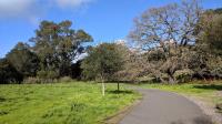
A view of the trail along the main paved loop.
From the parking lot, there is a quarter mile kidney-shaped loop paved path that can be enjoyed by visitors of all capabilities. Some large oaks dot the perimeter of the path while the center is largely an open grassy area.
Radiating out of the main loop are two paths leading south towards the remainder of the preserve's trails. The southernmost spur is also paved and continues for about 1/10th of a mile to a mini cul-de-sac. From this point a dirt path continues south to "The Point", the southernmost point in the preserve.
Several other trail segments, all dirt trails at this point, split and join up in the area, occasionally providing short spurs with access to the Napa River as it meanders around the park.
In attempting to hike all main segments a hiker is likely to log less than 1.5 miles. There's not a great hike here, but a pleasant and mostly quiet spot to enjoy a more natural interaction with the Napa River in the center of town.