Oat Hill Mine Trail

Trail
8.25 Miles
2000 Feet
Free
4stars (4.00)3
3point5stars (3.67)
3stars (3.33)
No
Yes
Yes
No
Calistoga
Napa
More Info

History

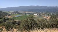
A view over Napa Valley vineyards and Calistoga only one mile into the hike.
This scenic path through the mountains overlooking Napa Valley was not put into place to provide a vigorous outing by locals and visitors, though it does, and the path was not chosen to highlight spectacular views over wine country, though they do exist. Rather, the road was put in place to support mining operations in the area and to avoid the high fees charged by nearby private roads.

There's no gold in these hills (well, not in usable quantities) but Cinnabar, a red shiny mineral that contains mercury sulfide. The mercury extracted from the rock would often be used for some gold mining operations. The trail's namesake Oat Hill Mine was at one point the sixth largest mine of its kind in the world.

The trail features some nice views within the first mile of the trailhead, but if you go higher the views of Napa Valley get better.
Getting the ore out of the area proved to be time consuming and costly. No easy routes from the mines to the railhead in Calistoga existed. An initial route required the paying of a toll to travel along a private roadway. The path that became known as the Oat Hill Mine Trail was a publicly funded path that took 20 years to go from concept to completion in 1893.

Alternate routes opened up and by the 1930's and 1940's traffic along the road dwindled. Maintenance on the road ceased. On top of that, mining at Oat Hill and other sites in the area started to wind down their operations by the 1960's. Homesteaders along the path moved out or sold to developers who eventually made futile efforts to build housing projects on the hills.

Though abandoned by miners and residents, the path became the playground for off road vehicles and hunters looking for a quicker path into the backcountry. The noise and deaths that occurred from jeeps driving on the ever more perilous path led the county and community to repurpose the trail for hikers and cyclists.

The Trail

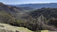
The trail crosses over the spine of a ridge and opens up views of Napa Valley more to the north.
The main trailhead lies along Highway 29 near the intersection with Silverado Trail. There are very few parking spaces here and most spots are likely to be filled up on the weekend. Be prepared to park along the road. If parking on the opposite side of the highway be sure to cross with care.

The trail is nearly continuously ascending from the trailhead and thus can be challenging. The trail surface starts out muddy and can get a bit squishy after a rain. But the softer surface will soon give way to a consistently rocky path for the remainder of the trail. Farther up the hill, on trail surfaces consisting of solid rock, be on the lookout for ruts carved into the rock by the metal covered wheels of the wagons used to haul supplies and ore over the path.

Decent views over part of Napa Valley are available at the half mile and 1 mile points of the trail for those looking for a quicker outing. And what would one expect to see when looking over Napa Valley from above? Vineyards, of course!

There are mile markers every mile and at trail junctions where they do occur. What is a little odd is that there are two markers for mile 1! Both appear very official and roughly the same age. According to our GPS we recorded the markers at approximately .97 and 1.08 miles. So split the difference! Who's to say which one is right?

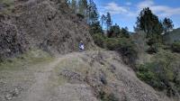
Many segments of the trail hug a steep rock wall on one side.
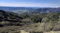
For the first couple of miles there is decent tree cover over a good portion of the trail intermixed with open segments. That begins to change after about 2.5 to 3 miles where the terrain becomes even rockier and fewer trees means more Sun beating down on the traveler. The upside of this becomes the more frequent views over ever larger swaths of the valley. As one looks uphill you'll also see more dramatic rock formations either along the trail itself or along the Palisades to the northwest leading towards Robert Louis Stevenson State Park.

A close look at the rock formations along the trail give hint to some of the volcanic activity that formed the area.

There's a mix of vegetation that varies by distance from the trailhead and the elevation as one progresses along the trail. Grey Pines feature prickly pine cones the size of softballs. The larger ones could do some serious damage if they fell on a person's head.

At the midpoint of the trail, approximately 5 miles from the trailhead, sits Holm's Place. Karl Gustov Holm acquired 160 acres along Oat Hill Mine Road and built a log cabin in this mountain pass in 1893. A new house was built in 1896 and other structures including a barn were added to the mix. Only a few low wall and foundation stones remain of the complex of buildings that once were here.

Walking up to Holm's Place the rocky, desolate trail does not provide much confidence that someone could make a living from farming here. But the saddle of land in the shadows of the Palisades flattens out and provides suitable soil for agricultural pursuits such as growing fruit trees. A few of Holm's apple trees are said to survive to this day.

The back half of the trail leads from Holm's Place to the trailhead at Aetna Springs Road. The trailhead there starts a bit higher than 2200 feet above sea level, which means it should be less vertically challenging and even a bit shorter on top of that. The two downsides with that segment of the trail is that getting to the trailhead is more difficult and it's also closed from late summer into fall due to high fire hazards and deer hunting season. Be sure to check for trail availability before heading out during that time of year.

Photos
Caves
Several caves can be seen on the opposite side of the canyon. (Photo by Austin Explorer)
Headed back
Coppertone heading towards the trailhead after the turnaround point near Holm's Place. (Photo by Austin Explorer)
Swartz Canyon
Much of the eastern trail provides fantastic views of Swartz Canyon which empties into Pope Canyon. (Photo by Austin Explorer)
Shelter
Numerous caves and overhangs can be seen from the trail. This one sits just off the trail. (Photo by Austin Explorer)
Rocky path
The Oat Hill Mine Trail is rocky and sometimes very rocky. (Photo by Austin Explorer)
Trail View
Coppertone hiking along the trail. (Photo by Austin Explorer)
Lower view
If one doesn't want to put in too much of an effort, views like this one are available within one mile of the trailhead. (Photo by Austin Explorer)
Headed down
Coppertone descends down the trail towards the trailhead. (Photo by Austin Explorer)
Rounding the top
Near the main junction the trail circles around the sheer walls of rock of the area's high point. (Photo by Austin Explorer)
Rock Formations
The higher the trail gets the more rocky the terrain. (Photo by Austin Explorer)
Coppertone on the trail
Coppertone on the trail. The Palisades Trail leading to Robert Lewis Stevenson State Park probably follows the ridge of rock in the distance. (Photo by Austin Explorer)
The goal
A view from the trail looking at where we're headed. Our turnaround point lies a bit beyond the highpoint visible in the distance. You can also see the trail up ahead traversing the slope from left to right. (Photo by Austin Explorer)

Only showing last 12 photos. View All Photos

Log Entries
Getting there was half the fun?
By Austin Explorer on 2/11/2018
Rating: 4stars Difficulty: 4stars Solitude: 4stars
Distance: 8.01 Miles Duration: 3 hours, 43 minutes

After completing the first half of the trail on the Calistoga side of the mountain Coppertone and I were eager to see what the eastern half of this trail had to offer.  The drive to the trailhead was an adventure all its own.  It's about a 1.5 hour drive from Sonoma Valley but the real adventure is the last few miles that take place on a single lane dirt road headed up the mountain.  I'm not entirely sure what we would do if we encountered a vehicle headed in the opposite direction but thankfully that did not occur.

As you would expect on the Oat Hill Mine Trail, the surface is very rocky.  However, to get to the pass that marks the halfway point there is far less elevation gain.  There's a bit of up and downs but 400 feet of elevation difference is less challenging than the west segments almost 2000 feet.

The solitude is far higher here on the eastern half of the trail.  In almost 4 hours of trail time we came across only two other people.  The canyons opening up into sparsely populated Pope Canyon meant quiet solitude for the entirety of the hike.

A surprise birthday party later in the day required us to push the pace a bit to make it back home in time.  It would have been nice to have a bit more time to take in the views, which were spectacular.

Second time's the charm
By Austin Explorer on 1/28/2018
Rating: 4stars Difficulty: 4stars Solitude: 3stars
Distance: 10.11 Miles Duration: 5 hours, 59 minutes

During our first attempt at this trail we had to turn back earlier than expected due to some unexpected heat and blisters on Coppertone's feet.  This time around we tackled the trail a bit earlier in the year and had some extra tape for Coppertone's heels, just in case.

We didn't bite off more than we could chew, but we probably still bit off more than we should have at this point.  For a number of reasons we were a bit out of trail shape and a 10 mile hike might not have been the best choice.  But we were determined to get from the trailhead along Highway 29 to the Holms Place junction.  We would not be denied!

There was a great deal of maintenance on the trail that has recently been done.  A large number of tree limbs and even entire trees that had been trimmed back from the trail.  In some cases the limbs and brush was piled up along the trail's edge.

We saw a number of crows and turkey vultures from the trail and even a single woodpecker in a tree.  But strangely, we don't recall seeing, or hearing, any other birds during the entire hike.  Once we came to realize this it was a bit spooky.  We were never able to really come up with an explanation for it.

Heel blisters prevent us from continuing
By Austin Explorer on 7/2/2017
Rating: 4stars Difficulty: 3stars Solitude: 3stars
Distance: 4.57 Miles Duration: 2 hours, 5 minutes

Coppertone and I had planned to do a wine tasting at a specific tasting room in St. Helena so we decided to try out this trail which we had just found out about not too long ago.

The trail was rocky from the start and immediately starts ascending.  But overall, the steepness of the trail is not too challenging.  Views at 0.5 and 1.0 mile marks present some nice views over parts of Napa Valley and numerous vineyards.

The warmer temperatures and some failing tape caused blisters on Coppertone's feet leading us to cut the outing short.  We need to pack some paper tape in our backpacks to avoid such a situation in the future.

Recommended Item
Recommended Item Hiking California's Wine Country: A Guide to the Area's Greatest Hikes
Bubba Suess
List Price: $24.95 Your price: $21.16 Buy Now
Hiking California's Wine Country covers 67 hikes in the area for hikers of all abilities. Up-to-date trail information and miles and directions will be featured throughout, as well as sidebars on local culture, trivia, and wildlife. GPS coordinates are available for all trailheads.