Bluff Top Trail

Trail
3.30 Miles
99 Feet
N/A
3stars (3.00)1
2stars (2.00)
3stars (3.00)
No
No
Yes
Yes
Stewarts Point
Sonoma
More Info

Location

The Bluff Top Trail hugs the rugged coast of Sonoma County from Gualala Point Regional Park in the north to Walk On Beach in the south. This also roughly parallels CA Highway 1. Access to the trail is available at the northern and southern ends and via the Salal Trail roughly at the trail's midpoint.

History

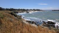
A view of the Pacific Coast from the Bluff Top Trail.
The Bluff Top Trail provides a physical reminder of a contentious issue that has played out in California for decades - access to the shore. In the 1960s a development group purchased a large segment of land and proposed an extensive housing development. Opposition to the development ultimately led to the creation of the California Coastal Commission and public emphasis on access to the Pacific Ocean. Sonoma County Regional Parks has a public access easement through a portion of the Sea Ranch and that's how the trail became possible.

Interpretive markers along the trail provide a bit of background into the history of the area. Not so surprising uses of the coast and surrounding lands include farming, raising cattle and lumbering of Redwoods from the uplands. The bigger surprise is that the land occupied by Sea Ranch now used to be an Navy bombing range! Between 1944 and 1946, Navy pilots flying out of Santa Rosa who were finishing up their training used Gualala Point Island as a guide point to zero in on a spot about 50 yards inland to dive bomb.

The Trail

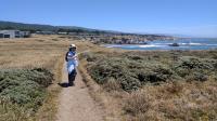
Coppertone on the trail showing the homes lined up throughout most of the trail's length.
The easiest and most abundant parking for the trail is within Gualala Point Regional Park at the northern terminus of the trail. From the park's information center the trail heads toward the shore and then south. A short spur to the north leads to a spot called Whale Watch Point.

Most of the trail's length hugs the cliff top along the Pacific Ocean coast. To the east lies the homes in the Sea Ranch development. Though a couple of clumps of trees and shrubs will appear periodically, the hiker can generally expect to be fully exposed to the Sun and wind. Sunscreen is highly recommended.

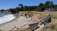
Coppertone looks down on one of the small beaches found throughout the trail's length.
Northern Sonoma County has mostly rugged, rocky shorelines. But small bits of secluded beaches appear here and there, dependent upon the occasional landslide and the typical currents along the coast. Along the trail one can see some of these landslides represented by cuts into the bluff. Those that are still unstable are fenced off and the trail slightly rerouted ever so slightly inland.

There's sometimes an uneasy feeling walking past the houses at Sea Ranch. There's plenty on nature on the sea side of the trail and the houses on the land side are not so tightly packed as remove all signs of nature. But what's a little strange is the quietness of the neighborhood. It appears a good percentage of the homes are summer retreats that get used a few times a year. Some are quite clearly sealed up for an extended period of time. It's like walking in one of those science fiction movies where all humankind has disappeared off the face of the Earth.

The trail ends at Walk On Beach. There's a nearby access trail that leads to the highway, so that's an alternative access point. Though a trail continues further south at that point the trail enters the property of Sea Ranch itself and so if you're not a resident you don't have access.

Photos
Walk On Beach
Publicly accessible Walk On Beach is the trail's turnaround (or starting) point. (Photo by Austin Explorer)
Another Shoreline View
One of the many shoreline views available along the trail. So many, but one never seems to grow tired of them. (Photo by Austin Explorer)
Sun and wind exposure
Coppertone and trail showing typical conditions, relatively flat and fully exposed to the Sun and wind. (Photo by Austin Explorer)
Temporary Shade
The trail occasionally slices through thick bunches of trees and shrubs with tunnels carved through. (Photo by Austin Explorer)
Shoreline
Looking back from Gualala Point. A small beach sits at the end of the cove to the right. The trail thus far follows the shoreline from right to left. (Photo by Austin Explorer)
Gualala Point Island
Coppertone at Gualala Point with Gualala Point Island in the background. (Photo by Austin Explorer)
Gualala River
North of the trail, at the northern edge of Gualala Point Regional Park a sand spit temporarily cuts off the Gualala River from the ocean. (Photo by Austin Explorer)
Log Entries
First Trail Challenge 2017 Hike
By Austin Explorer on 7/16/2017
Rating: 3stars Difficulty: 2stars Solitude: 3stars
Distance: 8.44 Miles Duration: 4 hours, 32 minutes

This was the first hike Coppertone and I did as part of the 2017 Sonoma Regional Parks Trails Challenge.  We'll probably only end up doing their 5 hike challenge.  Their intreaguing 50th anniversay challenge might be more than we can manage given our schedule through the rest of the year.

We started off at the north end of the trail in Gualala Point Regional Park.  There is an entry fee to get in there, but we had a parks pass (highly recommended) and didn't want to contend with any parking issues at Walk On Beach to the south.

It was a little strange walking past the quiet, seemingly empty houses at the Sea Ranch development.  We saw more seagulls than people in or around their houses.  It was like a weird scene in a sci-fi movie where everyone except the protagonist disappears.

The trail is very easy to follow along and there's not much elevation gain other than a creek crossing here and there.  There were a number of markers with historical tidbits about the various activities that took place on the land in the past, including bombing runs by aircraft during World War II!

The win was incredibly strong today, particularly when hiking back up to Gualala Point Regional Park.  If we didn't have straps on our hats we would have lost both of them for certain.  On the plus side, that helped keep things much cooler than the temps were further inland, which is why we picked this hike in the first place.

Recommended Item
Recommended Item Coastal Trails of Northern California: Including Best Dog Friendly Beaches (Falcon Guides)
Linda Mullally, David Mullally
List Price: $29.95 Your price: $17.95 Buy Now
Coastal Trails of Northern California Including Best Dog Friendly Beaches is a hiking guide to between 40 and 45 of the best coastal trails in Northern California including dog friendly beaches. Look inside for detailed hike descriptions, miles and directions, maps, and color photos for each hike. Hike descriptions also include history, local trivia, and trailhead GPS coordinates. Read more