Cloverdale River Park

Trail
1.00 Mile
N/A
Free
2stars (2.00)2
1star (1.00)
2point5stars (2.50)
Yes
Yes
Yes
N/A
31820 McCray Rd.
Cloverdale
Sonoma
More Info

Location

Cloverdale River Park is a simple, flat concrete path that follows the Russian River just east of Cloverdale, CA. There are two possible trailheads at both the northern and southern entrances.

Parking at the Sonoma County Regional Parks' Cloverdale River Park parking lot off of McCray Road is not free, but the area is well maintained and there are picnic tables and a restroom nearby. Parking at the southern end of the trail just off of Crocker Road is free but has no amenities.

History

According to Sonoma County Regional Parks (SCRP), in 1999 Cloverdale was the only incorporated area within the county that did not boast of a regional park. In concert with the City of Cloverdale, which owns the southern half of the park surrounding the water treatment plant, and the Sonoma County Agricultural Preservation & Open Space District (SCAPOSD), which purchased the northern half of the park's land the SCRP is now tasked with maintaining the park for all to enjoy.

Surprisingly, this park is the only point of public access to the Russian River between the Mendocino County line to the north and the city of Healdsburg to the south.

The Trail

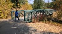
Coppertone approaches a bridge over a creek crossing along the trail.
The trail is paved throughout its course and completely flat. It should be ADA compliant, particularly if you park at the northern end of the park where handicapped parking is available.

The trail following the course of the Russian River. Depending on the spot along the trail and the time of year you may, or you may not, be able to descend a short distance down to the river itself. When water levels are not high the more diminutive stream meanders along the riverbed and at times occupies a channel on the opposite side of the bank from the trail giving the hiker the impression that the river has run completely dry.

The trail surface is paved and flat throughout its course.
Near the southern end of the park, the trail passes through some buildings and storage facilities for the area's water treatment plant. It's a bit of an industrial outlier compared to the remainder of the hike, but doesn't detract from the outing too much.

Sonoma County is in the heart of Wine Country. So it should come as no surprise if you happen to find wild grape vines growing in spots along the path.

Highway 101 is not far off the west and thus car noise is fairly omnipresent though not too loud. Thus, solitude is not particularly in abundance even if there might not be many people using the trail.

At the southern terminus of the trail lies an interesting cemetery with lots of historical gravestones. One can add some mileage and elevation gain by walking through the plots as the cemetery climbs a hill that occasionally provides scenic views over vineyards on the opposite side of the Russian River.

Photos
Story Walk
Temporary Story Walk display along the trail. The featured book was "I Know the River Loves Me". (Photo by Austin Explorer)
Trail View
The paved trail as it nears a bridge over Oat Valley Creek. (Photo by Austin Explorer)
Cloverdale Cemetery
The interesting Cloverdale Cemetery at the southern terminus of the trail can add some extra mileage to your walk, if you are so inclined. (Photo by Austin Explorer)
Mountains
A view from the trail looking towards to the Mountains west of Cloverdale. (Photo by Austin Explorer)
Log Entries
Sonoma County Trails Challenge Completed!
By Austin Explorer on 6/30/2019
Rating: 2stars Difficulty: 1star Solitude: 3stars
Distance: 2.32 Miles Duration: 52 minutes

Coppertone and I completed our 2019 Sonoma County Trails Challenge with this short hike.  We had been here before and the parking in the official parking lot looked nicer than parking along the road at the southern end of the trail.

In the first quarter mile we enjoyed the temporary signage that discussed a children's book about rivers entitled I Know the River Loves Me.  We had a bit of fun hopping like frogs, flapping our arms like butterflies and identifying things that did and did not belong in nature.  Naturely, we saw no one else around when we did these things!

After the hike it was time to go home and fill our our trail log for the challenge.

Walking along the river and through history
By Austin Explorer on 8/19/2017
Rating: 2stars Difficulty: 1star Solitude: 2stars
Distance: 4.32 Miles Duration: 2 hours, 51 minutes

The trail is a simple paved path following the Russian River.  It's rather short, slightly scenic but near constant road noise from Highway 101 takes away from the experience.  Might be a nice resource for nearby residents or a quick walk for visitors to Cloverdale or Alexander Valley who are in the area for other reasons.

It's grape picking time in wine country and some wild grape vines we saw near the parking area looked ripe for the picking.  Obviously the area is well suited to viticulture given that untended plants seem to flourish.

At one point we were almost taken out by a squirrel who may have been fleeing a rival when he appeared just a foot or two in front of us on the trail.  He quickly got his wits about him and scurried up a nearby tree.  Fence lizards were ever frequent on the edges of the trail, often perched on rocks trying to soak up the Sun's heat.

What really consumed our time here was the wandering we did around the cemetery situated at the southern end of the trail adjacent to the parking area.  We found grave sites as early as 1862 and many interesting headstones.

Coppertone and I planned to walk this trail, run a few errands and then try another hike in nearby Healdsburg but with all of the time spent in the cemetery we had to cut our walking/hiking short.  No complaints though.

Recommended Item
Recommended Item Day Hikes Around Sonoma County: 125 Great Hikes
Robert Stone
Your price: $21.95 Buy Now
Day Hikes Around Sonoma County is a collection of 125 of the county's best day hikes, providing access to both well-known and out-of-the-way greenspace. Hikes are found along the Pacific Ocean, across the coastal ridges, into wide valleys, and through thick forests. A third of the hikes are located along the coastline, accessed by Highway 1, which connects the coastal towns as it snakes along the oceanfront cliffs and bluffs. Many coastal access points that are not easily recognized from Highway 1 are clearly described. The remaining hikes explore the inland mountains, hillsides, and valleys through numerous state parks, regional parks, and undeveloped land. Highlights include fog-shrouded redwood forests, creekside canyons, wildlife sanctuaries, lakes, tidal bays, wave-pounded coastline, and sweeping panoramic views. A wide range of hikes accommodates amateur to avid hikers, from beachfront strolls to canyon treks. Straight-forward directions and clear maps accompany all hikes. A thorough index includes cities, trails, and points of interest.