Sentinel Dome Loop

Trail
7.04 Miles
774 Feet
N/A
4stars (4.00)2
4stars (4.00)
3stars (3.00)
No
N/A
N/A
No
TUOLUMNE MEADOWS
Mariposa

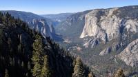
Looking west down Yosemite Valley from the Pohono Trail. El Capitan is on the right.
The trailhead for this hike lies along Glacier Point Road and is shared with the Taft Point and The Fissures Trail. The hike to the top of Sentinel Dome can be popular and the parking area along the road can get full. Plan on showing up early to ensure a spot.

Soon after the trailhead there is a T intersection. There are two options here, depending upon your desired hiking distance and available time. For a quicker path to the summit turn right for an out and back to Sentinel Dome. The hike described here will include the peak but also features a trip around the base of the dome. So turn left to start the circumnavigation.

A large mound of white quartz can be spotted to the right of the trail. When the trail intersects with the Pohono Trail turn right.

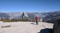
Austin Explorer and Half Dome as seen from the summit of Sentinel Dome.
The trail's travel through wooded terrain will end as it nears the edge of Yosemite Valley's rim. Here you'll find numerous breathtaking vistas up and down the valley. El Capitan will be visible throughout. Half Dome will have to wait for the summit.

There's a little bit of confusion with a number of trail segments near the point where the Pohono Trail intersects with the path to the summit, but the signs pointing to the Sentinel Dome should clear things up fairly easily.

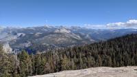
Looking off far into the distance to some of the high Sierras from Sentinel Dome.
The slope can be quite steep at times and can be a bit tiring after several miles of hiking. The tree cover holds up on this side of the dome through a good part of the last climb to the top. When nearing the peak the trees dissipate and the largely barren solid rock mound of the summit becomes apparent.

The views from the top are spectacular. Not even nearby Glacier Point can match Sentinel's views of El Capitan, Half Dome and Nevada Falls.

When descending from the dome look for signs pointing to the right towards the trailhead. The trail passes through alternating segments of forested patches and more sparsely vegetated rock covered fields. By the time one gets back to the T intersection encountered earlier the trailhead will be visible to the left.

Photos
Wind swept
A wind swept tree atop Sentinel Dome. El Capitan can be seen to the left. (Photo by coppertone)
Trail View
A view along the Sentinel Dome trail as we headed back to the car. (Photo by Austin Explorer)
Half Dome and Nevada Falls
A closer look at Half Dome with Nevada Falls to the right. (Photo by Austin Explorer)
Half Dome
Half Dome as seen from Sentinel Dome. (Photo by Austin Explorer)
Pohono Trail
Coppertone checks out one of the many viewpoints to be found along the Pohono Trail segment of the loop around Sentinel Dome. (Photo by Austin Explorer)
Log Entries
Even Better Views
By Austin Explorer on 10/8/2018
Rating: 4stars Difficulty: 4stars Solitude: 3stars
Distance: 7.04 Miles Duration: 5 hours, 8 minutes

Coppertone and I decided to complete this hike after our Taft Point and the Fissures Trail hike since we were already here.  Since we'd been out of hiking shape for some time that might not have been the best idea, but we managed to finish it all and were rewarded with some views even better than at Taft.

Starting from Taft on our way back meant we ended up with more elevation gain than if we had just done this hike by itself.  Our first part of the loop was along the Pohono Trail that hugs the cliff edge on top of the valley, providing several spots along the way featuring sweeping vistas of their own.

On the east side of the loop a trail heads to the dome's summit.  The path can be quite steep in spots, but the overall distance to the top is not that terribly long.  After hiking a bunch of miles leading up to it added to the challenge for us.

The top of the dome is mostly bare of trees and vegetation, providing 360 degree views of the surrounding terrain.  One can see both El Capital and Half Dome from here and look down on both of them.  Also visible in the direction of Half Dome is Vernal Falls and Nevada Falls, a target for a hike later this week for us.

Views up and down the valley
By coppertone on 10/8/2018
Rating: 4stars Difficulty: 4stars Solitude: 3stars
Distance: 7.04 Miles Duration: N/A

Hiked this one with Austin Explorer.

Recommended Item
Recommended Item Hiking Yosemite National Park: A Guide to 61 of the Park's Greatest Hiking Adventures
Suzanne Swedo
List Price: $22.95 Your price: $17.99 Buy Now
Lace up your boots and sample sixty-one of the finest trails Yosemite National Park has to offer. Fully updated and revised, and including color maps and photos throughout, Hiking Yosemite National Park features everything from short strolls and day hikes to multiday backcountry treks, every one of which will treat you to some of the world’s most stunning scenery and allow you to get the most out of this remarkably diverse natural wonderland.