Cat Hollow Trails

Trail
1.81 Miles
N/A
N/A
1point5stars (1.50)11
halfstar (0.83)
1star (1.00)
Yes
Yes
Yes
N/A
Round Rock
Williamson

Getting there: From I-35 in Round Rock take the RR 620 exit and head west on 620. Turn right onto Great Oaks Drive. Look for the park on the right after a few blocks. Ideal parking is behind the fire station and community center.

The Hike: The Cat Hollow Trails are a set of three connected trails segments that also go by the names Community Park, Liberty Walk Greenbelt and Cat Hollow Park. Like typical parks one can find open fields, playscapes, playing fields, and a recreation center. The park also boasts an easy, partially paved trail, perfect for afternoon strolls.

The trail begins along Great Oaks Drive at the waypoint "Trailhead". The first half of the trail is paved, so those looking for easy going are in luck, and those looking for a rougher experience need to look elsewhere. Generally, the terrain is flat and the sparse tree cover means little shade.

Look for this windmill next to the main trailhead at the park. It's behind the activity center and fire station.
The waypoint marked "Alt-TH" is actually the recommended trailhead and where most of the locals park. The parking area is located behind the fire station and recreation center.

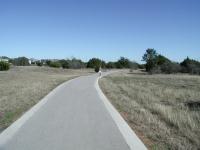
The trail near the trailheads is paved. Go further out and you'll get granite.
Given the flat terrain, the waypoint "Overlook" may be somewhat generous, but there is indeed a slight slope downward looking into the slight depression that drains to the northeast. In the distance you can see an iron fence that was constructed to keep people out of one of the karsts in the area. Not only are karsts or caves ecologically sensitive because they connect directly to the area's groundwater below, but they are also important habitat for a small colony of bats, which help keep the neighborhood insect population under control.

Along the trail there's an overlook to provide a view of a karst or cave opening. A colony of bats is known to live there.
Soon after the overlook the trail splits. To the right the paved path continues back to Great Oaks Drive. To the left, the trail surface turns to gravel and the number of people on the trail declines somewhat. Still, one should not expect to get any solitude on this trail.

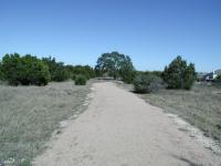
Farther from the trailhead the trail surface switches to crushed granite. Fewer folks venture this far out, though there's not much solitude
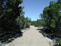
Like the rest of the park, the trail here is wide and wide open to the sky. Ashe Juniper (Cedar) and Live Oak dot the area, but rarely in suitable numbers or strategically placed to provide any shade. The backyards of houses to the right and left are apparent at all times, and occasionally dogs can be heard barking at "intruders".

The first trail segment ends at O'Conner Drive. The Liberty Walk Greenbelt segment starts on the opposite side of the street. Be careful crossing! Traffic moves very fast along the road and yielding to pedestrians doesn't seem to be on the drivers' agenda. The crosswalk sign situated here seems to do little good.

Despite the close proximity of houses, the Liberty Walk trail segment manages to provide a couple of tranquil spots.
The trail surface continues with crushed gravel throughout and is well maintained. Unlike some of the other adjacent segments, Liberty Walk has more Cedar, brush and tree cover, though open areas are the norm. The segment ends, appropriately enough, at Liberty Walk Drive.

At Liberty Walk Drive the trail crosses the street again and you're into Cat Hollow Park. The trail is once again paved and merely consists of a sidewalk around the park perimeter. There are the usual playscape, tennis court, basketball court and some room for picnicking. This park can also serve as an alternative trailhead.

The grand total mileage for the three segments of trails in Cat Hollow comes out to around 1.8 miles. It is about as flat as one can get in the Central Texas area, so it's got that going for it if you're looking for an easy stroll.

Log Entries
Short
By texaskdog on 4/5/2010
Rating: 1star Difficulty: 1star Solitude: 1star
Distance: 1.00 Mile Duration: 10 minutes

Not a whole mile.  On the other side of the park is the Liberty Walk & then the Community Greenbelt.  Great place to park and do all 3 hikes (takes about an hour) but park but itself isnt exciting.

Writeup is correct
By texaskdog on 4/5/2010
Rating: 1star Difficulty: 1star Solitude: 2stars
Distance: 1.00 Mile Duration: 20 minutes

Really a short connector from Cathollow to Community.  Park at Cathollow and hike all 3.

Nice hike
By texaskdog on 4/5/2010
Rating: 2stars Difficulty: 1star Solitude: 2stars
Distance: 2.00 Miles Duration: 35 minutes

I parked at Cathollow and did this after Liberty Walk.  Was the nicest portion of the 3 for sure.

pleasant trail thru neighborhood
By Ginger on 11/28/2009
Rating: 3stars Difficulty: 1star Solitude: 2stars
Distance: 2.50 Miles Duration: N/A

It was an absolutely gorgeous day when we went--70 degrees F with large puffy clouds.  I thought it was very pleasant.  There wasn't much shade, though, so I think that on a typical Texas day when temps get closer to 100 it would be far too hot to walk in the afternoon. Nice gravel path with trash cans and doggie mutt mitts at the major intersections. I liked the little bat observation deck.  We went down to the fenced in cave opening, but it looked like it was blocked with a large rock.  I guess there's still enough room for the bats to come and go, though.  Startled some does on our way down there.  LOTS of cacti to be wary of if you go off trail for any reason (but there really aren't any reasons, unless you're playing the disc golf course).

A short hike on a concrete trail in a small park.
By Guapo Gecko on 1/8/2007
Rating: 1star Difficulty: 1star Solitude: 1star
Distance: 0.50 Mile Duration: 10 minutes
The directions to the park are wrong. The park is located at the NW corner of Liberty Walk and O'conner. The "trail" is very narrow, hardly enough room for two people to walk side by side. If I go there again, it will be to take my kids to play, and not to "hike".
By rpears0n on 10/17/2004
Rating: N/A Difficulty: 1star Solitude: 1star
Distance: 2.00 Miles Duration: N/A
Pleasant walk
One of the best BCMUD trails
By Austin Explorer on 1/25/2004
Rating: 2stars Difficulty: 1star Solitude: 1point5stars
Distance: 1.00 Mile Duration: N/A
Of all of the Brushy Creek MUD parks that I hiked, this one is the best. Despite being just across the street from Community Park there are far fewer people on this trail. There's a bit more tree cover and several small segments where one can avoid having to look at a house.
Crowded
By Austin Explorer on 1/25/2004
Rating: 2stars Difficulty: 1star Solitude: 1star
Distance: 2.30 Miles Duration: N/A
Not much shade here and it can get somewhat busy, particularly near the trailheads. Trail surface is about half concrete and half crushed granite. All of the trail is easy.
A small, simple neighborhood park
By Austin Explorer on 1/25/2004
Rating: halfstar Difficulty: halfstar Solitude: halfstar
Distance: 0.50 Mile Duration: N/A

Not much to this one. The entire loop is paved and pretty much out in the open. It circles a basketball court, playscape and the like. Not much of a hiking experience, but not a bad stroll if you live in the neighborhood.

No shade at all.
By Centex Trekker on 2/1/2003
Rating: N/A Difficulty: 1star Solitude: 1point5stars
Distance: 0.75 Mile Duration: N/A
Not too crowded.
Recommended Item
Recommended Item Hiking Texas: A Guide to the State's Greatest Hiking Adventures (State Hiking Guides Series)
Laurence Parent
List Price: $24.95 Your price: $21.10 Buy Now
From the rugged Guadalupe Mountains in the west and the deep canyons of the Red River in the Panhandle to the lakes on the eastern landscape, the Texas backcountry is as spacious and diverse as the Lone Star State itself. This guide contains unforgettable hikes that suit all abilities and interests.