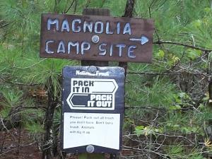
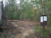
I am a longtime trail volunteer on the LSHT. I started my two day trip at the LSHT Trailhead #10 - Magnolia. Hiking East about 0.9 miles I came to the LSHT Primitive Campsite # 2 - Magnolia to camp for the night. Campsite has one tent pad, fire ring, signboard with maps & regulations, and a mailbox that has a campsite booklet with information - Emergency phone numbers, maps, and more. An isolated campsite that is beside an old tram grade that leads to Guthrie Rd in an emergency. Wonderful cool night.
Hiking East you come to a creek with Magnolia trees beside it. The recent drought has killed some trees, but still a beautiful spot. You come to a gravel road ( private ranch road). As you cross you decend into the San Jacinto River flood plain ***NOTE: The river bridge has been washed out! Trees often fall across the river and make for a tightwalk crossing. If river is in flood, Do Not enter water, as water can get 10 feet over bank level.
Once crossed, the trailsnakes through flood plain and then begins a steep climb that can make you breath hard. Trail continues to snake around crossing small creeks and gravel Forest Service road. Trail continues till it comes out on a pipeline and follows pipeline. Near mile marker 73 trail turns into forest off the pipeline and will snake its way to cross FM 2025 the the LSHT Trailhead #11- Iron Ore.
A great hike.Maps and info can be found at www.lshtclub.org