South Shore Playground to Armadillo Ridge and back
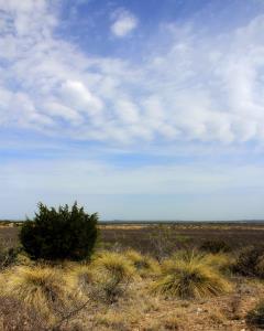
Looking North
This view is from Roller Coaster Trail as I look to the North. The houses to the left of the juniper bush are in the Highland Ridge Housing Area which abuts the park.
User: MikeHikes - 5/1/2014

Location: San Angelo State Park

Rating: 5stars
Difficulty: 2stars  Solitude: 5stars
Miles Hiked: 8.60 Miles  Elapsed Time: 4 hours, 15 minutes

Comments:


Out      Playground Parking Area > Tasajillo Flats Trail > Nature Loop Trail > Lanky Lackey Trail > Roller Coaster Trail > West Potts Creek Trail > Armadillo Ridge Trail > East Potts Creek Trail Signpost               4.9 miles

Return  East Potts Creek Trail > Burkett Trail > Winding Snake Trail > Chapparal Trail > Playground Parking Area    3.7 miles

This hike is described in detail in my prior log entry of 4/16/2014 and titled "South Shore Playground - Armadillo Ridge Loop".

The temps were in the low 60's, a light breeze, lots of birds singing and in the four hours I was hiking, I saw only one mountain biker on the trails - what more can you ask for ?!?

For those sharp eyed readers who noticed the mileage discrepancy between my prior log entry and this one - I use a pedometer and although I try to keep the same stride on each hike, it is apparent I do not.  One of these days I may get a GPS unit and record precise mileage but until then, my pedometer is what I use as a mileage recorder.


Log Photos
Looking North
Area around San Angelo State Park