To the top, almost, of Taylor Mountain
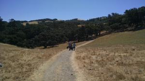
Tree Cover
There's not much tree cover on the Eastern Route leading up to Taylor Mountain. These patches of trees are fooling you!
User: Austin Explorer - 7/3/2016

Location: Taylor Mountain Regional Park and Open Space Preserve

Rating: 4stars
Difficulty: 4stars  Solitude: 2stars
Miles Hiked: 4.82 Miles  Elapsed Time: 2 hours, 38 minutes

Comments:

The forecast for the day said a high of 78, so we thought the exposed climb to the top of Taylor Mountain would not be too bad.  It certainly felt a lot hotter than that!  But Coppertone and I powered our way up the Eastern Route to the peak with only a few stops to rest and take a photo or two.

We spent a good deal of time at the top catching our breath, snacking, hydrating and enjoying the 180 degree view Santa Rosa and other areas below.

We were surprised at the number of hikers making their way up the mountain.  Sure, the weather was pretty good, but the trails here draw more visitors than we expected to see.  Strangely, the were almost no one on the twisting Sky Lupine Trail despite the more gradual ascent to the top it provides.

We descended down the Western Route and the Todd Creek Trail where the extra tree cover was a welcome relief from the Sun.  Just short of 5 miles back at the trailhead we decided to call it a day.


Log Photos
Tree Cover
Climb
More climbing

View

From the top

Sky Lupine Trail

Western Route

Todd Creek Trail
Recommended Item
Recommended Item Best Easy Day Hikes San Francisco's North Bay (Best Easy Day Hikes Series)
Tracy Salcedo
Your price: $9.95 Buy Now
This guide features twenty-two of the best short hikes in San Francisco's North Bay. Accurate maps and detailed directions make this pocket-sized handbook both easy to use and authoritative.