Park Mid-Section Burkett Park to Cougar Lookout Figure 8

Some of the burned area
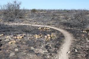
Although 1000 acres were burned it was not a complete burn. LOTS of dead mesquite trees still standing as well as other vegetation.
User: MikeHikes - 1/14/2018

Location: San Angelo State Park

Rating: 4stars
Difficulty: 1star  Solitude: 4stars
Miles Hiked: 11.00 Miles  Elapsed Time: 4 hours, 30 minutes

Comments:

Out      Burkett park > Suzanne's Trail > Roller Coaster > West Potts Creek > Armadillo > Playground > Bell's Point > Flintstone (N) > 5 Points Junction > Flintstone (N) > Cougar Lookout      6.1 miles

Return  Cougar Lookout > service road (SW) > River Bend (S) > 5 Points Junction > Turkey Creek > Armadillo > East Potts Creek > Burkett Trail > Burkett park    4.9 miles

Temps started at 40 and ended at 60, sunny, steady wind.

Park was closed for a few days for a controlled burn which happened to be in the section I hiked.  The trails are easy to find and so are a few deer/cow trails that may throw you off if you don't know where you're going.  Not all the vegetation has been burned so it's not a desolate vista.

Not many birds out and no animals were seen. 

A long, good hike but nothing special happened today.

NOTES

Water, shade, info kiosk and dry toilets available at Burkett park.

Water and shade available at Bell's Point.

Water, shade and info kiosk available at 5 Points Junction.

Info kiosk, shade and a bicycle repair station available at Cougar Lookout.


Log Photos
Some of the burned area
Area around San Angelo State Park
Recommended Item
Recommended Item Official Guide to Texas State Parks and Historic Sites: New Edition
Laurence Parent
List Price: $27.95 Your price: $24.27 Buy Now
Since it was first published in 1996, Official Guide to Texas State Parks and Historic Sites has become Texans’ one-stop source for information on great places to camp, fish, hike, backpack, swim, ride horseback, go rock climbing, view scenic landscapes, tour historical sites, and enjoy almost any other outdoor recreation.