Coppertone and I returned to Napa-Sonoma Marshes to map some of the few remaining trail segments we had not yet visited. This time is was largely Green Island. One might need to put Island in quotation marks because the highpoint of land is not entirely surrounded by water, at least not at this time. There's a short paved road that connects it from the mainland and there's even a very spacious parking lot there.
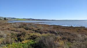
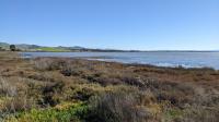
We parked along the street on the mainland since we also wanted to map the path parallel to the road to get to Green Island. Once we got to the island proper the reason for the parking area became more apparent. The island is popular with fisherman who dotted the shore. Green Island sports a house at its highpoint, which is fenced off. It was once the center of a large area of diked ponds used for salt production. The non-satellite view of the area on Google Maps still shows the uniform pattern of ponds once in place here. The Leslie Salt Company started production in 1961 and was eventually acquired by Cargill. California purchased the land in 1994 to begin the process of wildlife restoration which continues to this day.
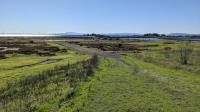
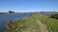
We walked on the path which sits atop the berm forming the perimeter of the island for abount half of its circumference. The we went back to our starting point to rewalk a stretch of the Napa River and San Francisco Bay Trail we had done on a previous trip. We did this to finish off a spur trail we had neglected to map the last time around. When the trail gets to the Napa River we turn left and walk as far as possible along a narrow spit of land with a well worn trail.
There is another congration of fishermen here and at least one of them seems to have had by far the best luck of any of them. Still squirming on the ground as we walked by was a fish the catcher estimated might be 40 pounds and he could very well have been right. One of his companions said it was a Perch, which might be true. But it also resembled a Carp to my untrained eye. Whatever it was, it was the biggest catch of the day we could see.
After reaching lands end we doubled back and to our car having mapped all of the known trail segments in the American Canyon area.