South Shore - Playground parking area to Armadillo Ridge Figure 8
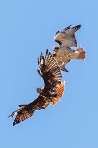
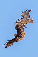
Aerial Combat
Not the sharpest photo but the best I could get while looking up as these two Red Tail Hawks dueled above me. One flew off, the victor stayed in place.
User: MikeHikes - 9/29/2022

Location: San Angelo State Park

Rating: 4stars
Difficulty: 1star  Solitude: 5stars
Miles Hiked: 10.70 Miles  Elapsed Time: 5 hours, 15 minutes

Comments:

Leg 1 -  Playground parking area > Horny Toad Trailhead > Tasajilla Flats > Nature Trail > Lanky Lackey > WS to LL Connector > Burkett Park     3.9 miles

Leg 2 -  Burkett Park > Burkett Trail > Potts Creek Trail > West Potts Creek Trail > Rollercoaster Trail > WS to LL Connector > Burkett Park    3.9 miles

Leg 3 -  Burkett Park > Winding Snake > Chaparral > Playground parking area    2.9 miles

Temp started at 60, ended at 82.  Sunny w/constant light, WSW breeze.

A very nice hike along trails that are dry, easy to see and traverse. A  good portion of the hike was on rocky trails or on trails that had dry, loose soil.  Animals spotted were numerous deer, two sets of javelinas, a group of turkeys and numerous birds, including raptors.  Fall is officially here because some of the mesquite tree leaves have turned yellow, purple thistle is blooming as well as Gayfeather flowers.  Additionally, I saw some transient Scissortail Flycatchers looking for food as they stop over briefly before continuing their flight to Southern Mexico and Central America for the winter.

NOTES

Water, shade, info kiosk, toilets and a bicycle repair station available at Playground parking area.

Water, shade, info kiosk and dry toilets available at Burkett Park.


Log Photos
Aerial Combat
Area around San Angelo State Park