South Shore - Playground parking area to Armadillo Ridge Figure 8
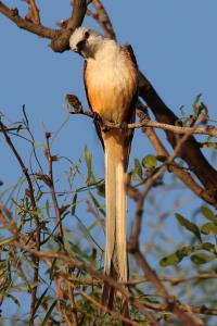
What'cha Doing?
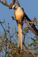
Right at the Chaparral trailhead high in a large mesquite tree, this Scissortail was illuminated by the morning Sun. As I stood there and snapped a few photos, he gave me this inquisitive look.
User: MikeHikes - 6/12/2024

Location: San Angelo State Park

Rating: 4stars
Difficulty: 1star  Solitude: 4stars
Miles Hiked: 10.70 Miles  Elapsed Time: 5 hours, 45 minutes

Comments:

Leg 1 - Playground parking area > Chaparral > Red Dam Loop > Chaparral > Winding Snake > Burkett Park     3.2 miles

Leg 2 - Burkett Park > WS to LL Connector > Roller Coaster > West Potts Creek > Potts Creek > Burkett Trail > Burkett Park    3.8 miles

Leg 3 - Burkett Park > WS to LL Connector > Lanky Lackey > Nature Trail > Tasajilla Flats > Playground parking area   3.7 miles

Temp started at 70, ended at 89.  Sunny with a few clouds. Fairly constant 0-5mph breeze from the SE.

Slow easy hike along dew dampened then dry trails that are easy to see and traverse.  Lots of birds out today especially Mockingbirds and quail.  I saw two Horned Toads at different locations which is unusual but very welcome to see.  Only animals I saw were deer and a couple of cottontails.  Overall, it was a very nice hike along familiar trails that I thoroughly enjoyed!

NOTES -

Water, shade, info kiosk, toilets and a bicycle repair station are available at Playground Parking Area.

Water, shade, info kiosk and dry toilets available at Burkett Park.


Log Photos
What'cha Doing?
Area around San Angelo State Park
BESbswy