Getting there: Head north on MoPac and take the Duval Road exit. Head west on Duval and turn right at AspenDale Road. Turn left onto Dorrsett Road. Look for a trail off to the left after a few blocks. Parking on Dorsett is not very practical, so turn back and park on one of the side streets. Alternatively you might consider parking in Balcones Park and covering this hike from the opposite direction we did.
The Hike: This hike takes the name of Balcones Park, but it actually begins outside of the park boundary, at least according to our maps. A well worn path starts along Dorsett Road at the waypoint "Trailhead" and follows the rail road track some distance to the right. When starting out there will be a Y in the path with one of the paths closer to the rail line. The proper path is the left option, though it at first appears more overgrown.
-small.jpg)
The start of the trail along Dorsett Road.
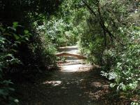
Starting off, the trail will consist of packed dirt, but most of the trail will be paved. A sewer or drainage line runs under much of the trail's length. Nothing in the line under the path emits any discernable odor though.
Soon after starting off we saw a common sight on this hike, a blown down tree across the trail. Since it had been weeks since Austin's last rain, much less storm, these roadblocks had been here for some time. One trunk was easily stradled and the second presented enough
of an obstacle to previous visitors that a well worn path around the fallen tree had developed. We did see at least one fallen tree that had been cut up and moved to the side
of the trail, so perhaps the maintainers are just behind schedule.

Several fallen trees presented obstacles along the trail.
At the waypoint "Tunnel 1" we reached the first of two trail under passes. The tunnels can be a little scary, in no small part due to the grafitti that adorns the concrete walls around and inside of them. Just to be on the safe side we probably would not recommend individuals pass through here at or near dark. In our four trips through the tunnels on this day we only encountered one man walking his dog after we exited one of the tunnels.

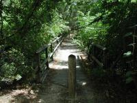
The bridges along the trail are safe, though one is missing some railing.
At the waypoint "Bridges" the trail will cross one bridge, turn right at the Y in the trail and then cross another bridge. One of the bridges offers another example of the neglect the trail is facing. Both bridges are fundamentally sound and very safe to cross. However,
one of them has lost about half of its railing and vandalism seems more of a likely suspect than the age of the materials. After crossing the second bridge look for a continuation of the trail along the creek bed below.

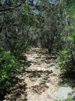
The hilly terrain along portions of the trail make for interesting scenery.
After passing through a the second tunnel at the waypoint "Tunnel 2" the trail condition and the scenary of the land around it improves. Nearby, you can take a break from hiking by searching for the
"Demise of a Dot Com" geocache, which lies close to the trail. This is an easy geocache to find and thus makes for a good first effort.
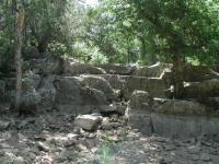
The terrain along the trail gets more rocky, though the trail itself remains quite easy. Near the waypoint "Bypass" we came across an interesting looking waterfall with one crucial ingredient missing - water. Being in the middle of a drought certainly did not help our chances of seeing the waterfall at work and from the lay of the rocks this waterfall is probably most picturesque during or after a heavy rain.

This waterfall probably looks wonderful with lots of water.
The bypass waypoint name is for the detour we took to avoid walking in stagnent water. The high rock face to the left discharges a small amount of water that gathers in puddles all along the trail here. To avoid this spot we simply stepped into the bone-dry creek bed and proceeded downstream for a short distance until the trail was dry again.
The trail actually did not end at the waypoint "Turnaround" where we headed back. However, the trail becomes very narrow at this point and poison ivy is prevalent, so continuing further in the summer is not advised.

By far, the most difficult portion of the hike was travelling up the rocky slope to the park.
We headed back with the intention of taking a side trail that leads into the heart of Balcones Park. The waypoint "Stairs" marks the spot at which the side trail breaks off from the main trail and heads straight up hill. This section of our hike helps push the difficulty rating up beyond the very easy level. The stairs are very rocky with lots of loose pebbles to make footing slighty difficult. The slope of the stairs provides a pretty good StairMaster-like workout.
When we got to the top of the stairs we found ourselves in an open field with picnic table and volleyball court without the sign of a single person. We continued towards the waypoint "Park", which involved crossing a small, but steep creek bed. Here a large playscape marked a more heavily used section of the park.
-small.jpg)
Our own private park at the top of the stairs.
There is the possibility that an alternate route back to the main trail could be found from this point. But we missed the opportunity to photograph the waterfall earlier, so we doubled back down the stairs and then onto the main trail and retraced our path back to the trailhead.
Our total trip time was about 2 hours and we covered 3.8 miles. Obviously the length and difficulty of the hike can be tailored by cutting out certain portions of the trail. This was an enjoyable hike but would be even more so with some maintenance on the trail.