Sonoma Valley Regional Park

Trail
3.20 Miles
N/A
$7.00
2point5stars (2.90)10
2point5stars (2.55)
2stars (2.20)
Yes
Yes
Yes
No
13630 Highway 12
Glen Ellen
Sonoma
More Info

The main, easy trail is a favorite with families and dog walkers.
Sonoma Valley Regional Park is located near the center of the Valley of the Moon on Highway 12. With the main parking area and trailhead so close to the highway the noise can be considerable. But walking a short distance into the park quickly nestles one into the embrace of a small canyon, greatly diminishing the annoying auto cacophony.

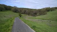
The park's main artery is the paved 1.2 mile long Valley of the Moon Trail. This ADA accessible trail follows the path of the diminutive Black Canyon Creek as it trickles its way towards the larger Sonoma Creek. The smooth and mostly level surface makes it ideal for walkers of all abilities.

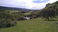
Overlooking Sutton Lake and some of the Sonoma Developmental Center land adjacent to the park.
If the park only featured its paved trail it might not be worth a visit for more than neighborhood families or pet owners. Thankfully, the park provides much more in the form of natural surface trails which largely parallel the more heavily used paved path. Packed dirt and rocky paths require a bit more effort but is more than made up for by several spectacular views of Sonoma Valley's two surrounding mountain ranges.

A couple of side trails join the main Valley of the Moon Trail with the rougher Woodland Star Trail uphill. Of these, the Milkmaid Trail is by far the nicer. There is far less Poison Oak than that found on the Buttercup Trail. To top it off, the trail junction between Milkmaid and Woodland Star is one of the nicer, more isolated spots in the park. There's good cover for shade and pretty views onto pastureland in the adjacent Sonoma Developmental Center (SDC).

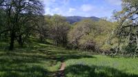
Looking back on the Woodland Star Trail towards Sonoma Mountain in the distance.
First opened in 1978, Sonoma Valley Regional Park has been on something of a growth spurt recently. In two separate transactions, 70 acres of land were acquired to bring the park's total size to just over 200 acres. One of those parcels along Highway 12 was purchased from SDC. Not included in any recent sale is the land around Suttenfield Lake, which many locals consider part of the park even if the official maps do not include it.

About half of the park's boundaries are shared with the Sonoma Developmental Center. Despite a few signs that seem to indicate access is restricted, there appears to be commonly accepted access between the two properties. A barbed wire fence marks the boundary but numerous openings exist throughout.

With the state of California announcing the closing of SDC it remains to be seen exactly how this will impact the regional park. Some of the better views from the park look over adjacent SDC land. There is great interest in maintaining much of the open space on the SDC property. What form that might take is still under discussion.

Photos
Trail View
Look uphill, away from Highway 12 and try to ignore the road noise. (Photo by Austin Explorer)
Recovering terrain
Fire ravaged parts of the park a few years back. Though scars and scorched limbs remain, things have largely recovered. (Photo by Austin Explorer)
Trail View
The Valley of the Moon Trail is paved and traverses from one end of the park to the other. (Photo by Austin Explorer)
Trail View
Hiking along the Valley of the Moon Trail. (Photo by Austin Explorer)
Evidence
The large number of woodpeckers in the area have made their presence known. (Photo by Austin Explorer)
Trail View
It's late enough in the year that all of the grasses have turned to a golden brown. (Photo by Austin Explorer)
Memorial
This touching memorial for victims of the 2017 fire lies along the Valley of the Moon Trail. (Photo by Austin Explorer)
Cougar Trail
Last year's fire has left its mark as the blackened tree trunks are still apparent. (Photo by Austin Explorer)
Damselfly Pond
Looking over Damselfly Pond as Cougar Trail goes from left to right. (Photo by Austin Explorer)
Trail View
No worries about high grasses at this point in the area's fire recovery. (Photo by Austin Explorer)
Cairn
A skillfully placed cairn of rock sits atop an old fence post along the trail. (Photo by Austin Explorer)
Green and black
Lots of evidence along the trail of regrowth (green) right next to areas needing a bit more time (black). (Photo by Austin Explorer)

Only showing last 12 photos. View All Photos

Log Entries
Very muddy Sonoma Valley Trail
By Austin Explorer on 12/26/2022
Rating: 2stars Difficulty: 3stars Solitude: 2stars
Distance: 2.10 Miles Duration: 57 minutes

During the drive out to our hike at Trione-Annadel two days ago, Coppertone and I saw the Sonoma Valley Trail in Sonoma Valley Regional Park.  We realized we had not yet hiked that segment so we made a mental note to come back for it at a later date.  That date was today.

The fog was quite thick and everything seemed a bit moist as we walked from the trailhead.  The trail surface was more than that.  It was very muddy!  This was a bit surprising since it had been perhaps a couple of weeks since our last rain.  Our boots were caked in mud in the end.

Sonoma Valley Trail parallels Highway 12, which runs along the middle of Sonoma Valley.  This close proximity to the road has a major drawback with the near constant road noise.  One can look uphill, away from the road and get a view of nature.  But one has to drown out the noise to try and make a tranquil scene of it.  A lone egret hunting uphill from the trail didn't seem to mind.  We saw him at the start and end of our hike.

There is the potential of views across the valley to the Mayacamas Mountains but the fog and haze was thick enough to block any sweeping views on this day.

We turned around at a sign that marked the end of the trail and doubled back.  We elected to walk a bit on the paved Valley of the Moon Trail to knock off some of the caked mud from our soles and to get a bit more mileage before calling it a day.

Simple stroll
By Austin Explorer on 4/3/2022
Rating: 3stars Difficulty: 1star Solitude: 2stars
Distance: 2.67 Miles Duration: N/A

Coppertone and I just headed out to Sonoma Valley Regional Park for a simple stroll on this day.  I didn't even bring my normal GPS, so I just recorded the walk on an app on my phone.

Getting a hike/walk in after days of rain
By Austin Explorer on 12/27/2021
Rating: 3stars Difficulty: 1star Solitude: 2stars
Distance: 2.67 Miles Duration: 56 minutes

Coppertone and I were anxious to get outside and stretch our legs after days of rain in the Bay Area.  Because everything was so damp we opted for a paved path at Sonoma Valley Regional Park.  We did a simple out and back along the Valley of the Moon Trail, which bisects the park between Highway 12 and Arnold Drive.

I'm not sure we'd been to the park when it was so green and lush.  All of the recent rains have made everything green.  In addition to Black Canyon Creek that parallels the trail the park seemed appointed with countless other smaller streams, many of which we had not noticed before.  All of them adding to the ample flow of Black Canyon before it empties into the larger Sonoma Creek.

Near the turnaround point of our hike we could hear the water in Sonoma Creek crashing through some rapids.  It made quite the racket.  By the time the creek got closer to Arnold it quited down quite a bit though the flow was impressive.

In the end we logged less than 3 miles of easy going walking but it felt really good to get outside.

Mapping out unhiked segments
By Austin Explorer on 9/2/2018
Rating: 3stars Difficulty: 3stars Solitude: 2stars
Distance: 3.22 Miles Duration: 1 hour, 27 minutes

Coppertone and I revisited this part to hike some trail segments we had not visited before.  We got a bit of a late start and paid for it with the heat but managed to do what we intended.

The Cougar and Black Canyon trails meander on the ridge just north of the more heavily used Valley of the Moon Trail.  Unlike that paved path on the valley floor the trails up here are rougher and provide a more "genuine" hiking experience rather than a stroll in the park.  Even so, the terrain is not terribly difficult here.

Throughout our hike we saw evidence remaining of the Oct. 2017 wildfires that burned throughout Sonoma County and this park in particular.  There's ample evidence of regrowth and renewal but the area has yet to return to its former lushness prior to the fires.  When on the Valley of the Moon Trail to connect our segments together today we stumbled upon a touching memorial of marked stones, all corraled in wooden frame, dedicated to those lost in the fires.

Though many trees made it alive through the fire, many did not and some that remain alive are weakened.  We think this fact may account for the very large number of woodpeckers we observed on today's hike, far more than we would normally expect to see in the area.

Guided Fire Ecology Hike
By Austin Explorer on 1/14/2018
Rating: 3stars Difficulty: 3stars Solitude: 2stars
Distance: 2.43 Miles Duration: 1 hour, 44 minutes

Coppertone and I went on a guided hike with the Sonoma Ecology Center to illustrate the area's ability to recover from the recent wildfires that ravaged the area.  Technically, the hike was in the Sonoma Developmental Center property but it's adjacent to Sonoma Valley Regional Park and many hikes there include a visit to Lake Suttenfield here.  Many locals also consider the undeveloped acres of the SDC part of the park anyway.

We found grass fields with verdant green abundant new growth.  Even trees and bushes with blackened trunks have started to show bud breaks for new leaves.  Still, there were dark black or whitish ash patches where the fire burned hotter and regrowth has not yet been able to establish itself.  In some cases trees that had previously fallen and burned on the ground left marks that reminded me of body outlines at a crime scene.

Overall, the area showed more improvement at this point than we were expecting.  We left feeling a bit better about the valley's ability to recover.  This wasn't the first fire to come through the area and it won't be the last.  In time it will look as beautiful as when we first saw it.

Hiking and drinking with the Sonoma Activity Group
By Austin Explorer on 9/15/2017
Rating: 3stars Difficulty: 3stars Solitude: 2stars
Distance: 2.14 Miles Duration: 49 minutes

Coppertone and I did another short hike at Sonoma Valley Regional Park with the Sonoma Activity Group and continued on into Glen Ellen afterwards for some drinks and conversation at the Wolf House.

The lake was notieably lower given the high temperatures and little rain as of late.  For the second time in a row when visiting we found young folks hopping the gate saying do not enter to go out onto the walkway leading out over the water.

Our previous visit to the Wolf House was not quite as pleasant given the mosquitos along the the creek, but tonight there no bugs and very pleasant weather.  

Sonoma Activity Group
By Austin Explorer on 9/2/2016
Rating: 3stars Difficulty: 3stars Solitude: 3stars
Distance: 2.37 Miles Duration: 50 minutes

Headed out for a hike around the lake with the Sonoma Activity Group once again.  This time the entire group opted for the slightly shorter route that hugged Suttenfield Lake instead of taking the slightly longer detour with the steeper climb.

Unlike previous outings we saw no one else on the trail, so there's a bit of a bump in solitude.

The water in the lake is getting noticeably lower than the last time we were out here.

Suttenfield Lake Loop
By Austin Explorer on 7/22/2016
Rating: 3stars Difficulty: 3stars Solitude: 2stars
Distance: 2.58 Miles Duration: 58 minutes

Coppertone and I joined about ten other folks with the Sonoma Activity Group for an early evening hike around Suttonfield Lake.  We started from the Arnold Drive trailhead just north of the Sonoma Development Center.  After a very brief segment of paved trail we hopped on the packed dirt trails leading towards the lake.

Most of the group elected to take an optional detour up a steep hill above the lake, so the mapped path doesn't match the lake exactly.

It was a fairly hot day, even for the early evening.  Every brief respite under the shade of the trees was welcome.  Still, we did a quick 2.5 mile loop in just under an hour, so we didn't suffer much.

Afterwards, the group drove to the saloon at Jack London Lodge in Glenn Ellen for some cold beverages and pleasant conversation.

Recommended Item
Recommended Item Day Hikes Around Sonoma County: 125 Great Hikes
Robert Stone
List Price: $21.95 Your price: $18.58 Buy Now
Day Hikes Around Sonoma County is a collection of 125 of the county's best day hikes, providing access to both well-known and out-of-the-way greenspace. Hikes are found along the Pacific Ocean, across the coastal ridges, into wide valleys, and through thick forests. A third of the hikes are located along the coastline, accessed by Highway 1, which connects the coastal towns as it snakes along the oceanfront cliffs and bluffs. Many coastal access points that are not easily recognized from Highway 1 are clearly described. The remaining hikes explore the inland mountains, hillsides, and valleys through numerous state parks, regional parks, and undeveloped land. Highlights include fog-shrouded redwood forests, creekside canyons, wildlife sanctuaries, lakes, tidal bays, wave-pounded coastline, and sweeping panoramic views. A wide range of hikes accommodates amateur to avid hikers, from beachfront strolls to canyon treks. Straight-forward directions and clear maps accompany all hikes. A thorough index includes cities, trails, and points of interest.