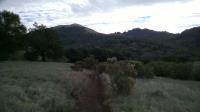
Heading up hill on Lower Bald Mountain Trail, not too far from the park observatory.
Sugarloaf Ridge State Park sits amidst a biologically rich crossroads for many of California's native flora and fauna. Here it's possible to catch glimpses of the state bird, the state tree, the state flower, and even the state rock. And yet, the park was an afterthought that almost never came to be.
The State of California bought the property in 1920 with the intention of damming up the creek to create a reservoir to facilitate the production of electricity for Sonoma State Hospital. Local opposition to the plan helped shelve the idea. It eventually became part of the state park system in 1964.
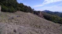
A guided hiking group heads towards a rocky overlook of Sonoma Creek valley.
The park contains the headwaters of Sonoma Creek. Though some relatively flat meadows bracket the creek itself, much of the park is made up of peaks along the Mayacamas Mountains that continue south towards the town of Sonoma. The high point in the park is Bald Mountain, which rises to 2,729 feet above sea level. That sits about 1,500 feet above the elevation of the park headquarters building.
The parks has somewhere between 20 and 25 miles (depending on the source of your information) of trails, ranging from paved paths to natural packed dirt and even some rocky scree-like segments.
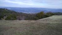
Napa Valley as seen from the summit of Bald Mountain.
The trail to the summit of Bald Mountain is mostly paved, which doesn't make for the most natural of hikes, but it does provide an smooth and even surface that might help to offset the difficulty from the steepness in places. There are alternate routes to the peak that take a more circuitous route (such as via the Gray Pine Trail) if one wants to avoid pavement.
About a third of the way up Bald Mountain lies Vista Trail. Not only does it provide a convenient turning point to complete and more leisurely loop back to the park HQ, it also features a prominent rock outcropping worth a visit all its own. I thought our guide called this feature Indian Rock. It juts up and out from the trail providing breathtaking and sweeping views of Sonoma Creek valley before it empties into the larger Sonoma Valley.
From the top of Bald Mountain one can easily peer into both the Sonoma and Napa valleys, two of California's most celebrated wine cultivation areas. On clear days one is also supposed to be able to see the Golden Gate Bridge to the south, the Pacific Ocean to the west and the Sierra Nevada Mountains to the east. The peak can be windswept and quite chilly compared to the areas just beneath it so dress in layers.
Gray Pine Trail provides a natural packed dirt and sometimes rocky path down the mountain to the east. The trail here is occasionally steep and requires some careful footing in places.
Like many other state parks, Sugarloaf was threatened with closure due to severe budgetary cutbacks. Team Sugarloaf non-profit organization was organized to take over operation. Please consider making an extra donation to the organization when you visit.