If you like hiking, you'll find plenty of trail in and around the Caprock Canyons State Park. There are a couple of scenic trails within the park itself as well as a LOT of lengthy trails along the Trailway, including The Plains Junction Trail (10 mi), Grundy Canyon Trail (12 mi), Oxbow Trail (10 mi), Kent Creek Trail (10 mi), Los Lingos Trail (5 mi) and Quitaque Canyon Trail (17 mi).
I only hiked within the State Park, not along the Trailway.
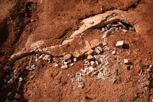
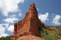
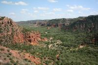
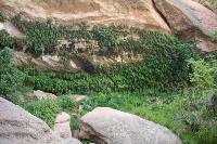
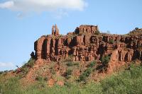
I camped at the South Prong Tent Camping Area, so my hike departed at the parking lot. This trail provided breathtaking vistas of cliffs and canyons, so remember to bring your camera! The Upper Canyon Trail was a fairly easy hike until you reach a section where you have to ascend an extremely steep and rugged cliff that takes you from 2,500 ft in elevation to 3,100 ft. It is not an easy climb, so I would not recommend it for elderly or people in below average health. I had just finished a 10 mile hike the day before in Copper Breaks State park so my legs were still aching, which made this ascent more difficult than usual. Once you get to the top, you are afforded some beautiful views, making the ascent worthwhile. From the top, you can continue along the crest on the Haynes Ridge Overlook Trail (2 mi) or to descend along Upper Canyon Trail towards Fern Cave. The cave sounded interesting, so this is the route I took. The cave proved to be an interesting site with large boulders and lots of moisture and ferns. At this point, however, I found the trail to be poorly marked and I got off trail several times once I left the cave. It wasn't a big problem, however, because at this point in the hike you are essentially hiking along the bottom of the canyon adjacent to a small winding stream. You can't really get lost since mountains surround both sides of you.
Once I got out of the canyon, I hiked back towards the North Prong Primitive Camping Area. There were several trail marker signs indicating trails like D1, C2, etc., but I was a little frustrated because these trail numbers do NOT appear on the provided trail map. Consequently, it would be easy for a hiker to take the wrong trail if he did not have a compass or good orienteering skills. Luckily, I took the right trail (Canyon Loop Trail) back to the parking lot and then along the paved road back to the South Prong Camping Area parking lot.
As I mentioned before, I found this hike to be challenging, but very rewarding in terms of scenery. Be sure to take plenty of liquids with you and allow enough time for a slower than usual pace.
There are several other trails in the park, such as Eagle Point Trail, the Lower Canyon Trail, Mesa Trail, and Canyon Rim Trail, but I did not hike these trails on this trip. This is a beautiful state park, so this provides me an excuse to go back! :-)