History
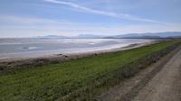
A view from the Sears Point Trail looking towards the mountains in Marin County, including Mount Tam.
Until relatively recently much of the marshland within the refuge was productive farmland. Over time levees and pumping stations drained the wetlands and a variety of crops were grown and cattle grazed. The benefits of marshland had not yet been appreciated. One side effect of draining marshes was also realized a bit late. The soil left after draining is fertile, but it is prone to subsidence once excessive water is removed. So the farms became ever more lower than the bay water adjacent to it. That means more pumping and levee building to keep nature at bay. In the end, it wasn't worth the effort.
Marshes like those found here are critical for many bird species, both those who live here year round and migratory birds who need a good stopover on their yearly odyssey. Wetlands provide protection from many land-based predators and ample food to refuel for the rest of their journey. Fish also use marshes as important fledgling grounds for their young to build up some body mass before heading out into the bay.
The Trails
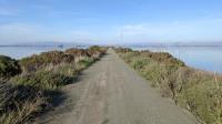
The Cullinan Ranch Trail sits on the line between the San Pablo Bay NWR on the right and the Napa-Sonoma Marshes WA on the left.
San Pablo Bay NWR consists of about 13,000 acres spread between the mouth of the Petaluma River and Mare Island covering parts of Sonoma, Napa and Solano Counties. Because a good portion of the refuge is marshland the areas available for hiking here are often separated by impassable areas.
Dogs are permitted in some small parts of the preserve and not in most. It's a bit tricky to figure out where they're allowed and where they aren't so safety's sake we'll just mark the preserve as not allowing dogs.
Lower Tubbs Island
If you want to get right on the shore of San Pablo Bay, this is the trail for you, even if it will be about a 3 mile walk to get there. Parking is on the south side of Highway 37 just east of the intersection with Highway 121.
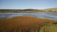
The mud flats near the Lower Tubbs Island Trail parking area were popular with foraging birds. Paradise View Vineyard lies in the distance.
The trail follows the flow of Tolay Creek, which starts to the north in
Tolay Lake Regional Park, runs along the trail as it empties into San Pablo Bay. During a good part of the trail the creek will be obscured by a levee.
The entire loop around Tubbs Island, which constitutes the 332 acre Lower Tubbs Bird Island Sanctuary, is no longer navigable. The views from near the shore are surprisingly good. Mount Tamalpais, Angel Island and Mount Diablo can be seen.
The ruins of old docks along the bay shoreline provide evidence of the way in which Sonomans of old used to get to and from San Francisco, via ferry.
Sonoma has 7 miles of shoreline along San Pablo Bay. Red-winged Blackbirds are numerous.
Sears Point
The Sears Point area boasts of some of the newest reclaimed wetlands in the area. In 2015 cranes were used to carve the first of many holes in levee to allow salt water to flow onto what had once been oat hay fields.
Birds and aquatic life are not the only benefactors of the move. Several miles of hiking trails line the edges of the marsh.