Tolay Lake Regional Park is one of the newest and largest parks in the managed by Sonoma County Regional Parks. At 3,400 acres there is plenty of room to spread out and get some solitude in the hills of southern Sonoma County.
History

The Cardoza Road Trail is one of the few trails in the park with any hint of shade.
The Tolay Creek valley has had cultural significance for Coastal Miwok Indians. It was thought to have been a sacred place used for multi-tribal gatherings. The lake was once the largest lake in Sonoma County prior to the damming of reservoirs. Starting in the 1800's farming and ranching altered the topology of the land and the shape and size of the lake changed as a result.
The park as it exists today consists of two parcels purchased separately by different entities. The Sonoma County Agricultural Preservation and Open Space District purchased the northern half of the park then known as Tolay Lake Ranch. The southern half of the park, known as the Tolay Creek Ranch was purchased by Sonoma Land Trust.
Agricultural pursuits continue to take place at Tolay Lake even after the park's opening. Cattle grazing and hay production are the most prominent, but you'll find some goats, chickens and a miniature pony in the old farm buildings adjacent to the main parking area.
Trails
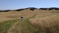
Coppertone heads down the mountain from Three Bridges Vista Point
The park occupies the space between two ridges that frame Tolay Creek as is flows towards San Pablo Bay. From one extreme of the park's boundaries to the other one can look to the opposite ridge a over a mile away and see nothing but parkland.
As mentioned above, there is still some active agriculture at Tolay Lake. The most obvious sign of that will be the cows dotted through the fields. In this case the cattle are not separated from the hikers by fences. You'll be walking through their home and you might encounter a few right on the trail. Many are leery of people but are not aggressive.
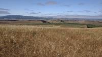
From Bay View Vista looking SE one can see Mount Diablo in the East Bay in the distance at center.
With cows come cow patties. You'll see lots of it laying about. Keep an eye where you plant your feet, particularly for the fresher samples left behind. Watching your step is also a good idea for the trail surface in general. The trails here are packed dirt tractor/jeep trails with sometimes large tire ruts. Twisting an ankle is a possibility so footwear to protect from such an event is recommended.
A prime consideration for hiking at Tolay Lake is sunscreen. There is precious little shade to be found on the trails. That does provide for sweeping vistas and miles-log views in multiple directions. But for exposed skin that can mean a bad case of sunburn. Cover up and/or apply sunscreen to protect yourself.
There is also no potable water on site. Bring all you'll need for your outing.
Mount Tam resides in the distance at the center of the shot. Rolling in the foreground at the hills of the park. On clearer days the Golden Gate Bridge can be spotted, part of the reason for this spot's name, Three Bridges Vista Point.
One of the few trail segments with any tree cover is the
Cardoza Road Trail adjacent to the trailhead. It starts behind the group picnic area. The trail follows a seasonal stream and is lined with Eucalyptus trees.
The longest trail segment is the West Ridge Trail which measures out to 3.55 miles. This segment provides access to two of the highlighted vista points in the park (Petaluma Marsh and Bay View Vistas). At its start the trail may be somewhat marred by the high tension power lines that practically overhang it, but the lines thankfully veer off in another direction when the trail intersects with the Burrowing Owl Trail sparing the remainder of the path.
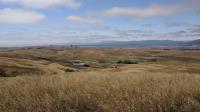
From the Three Bridges Vista Point, looking out over the width of Tolay creek's valley back towards the park's headquarters and our trailhead.
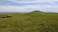
To enjoy the views at Bay View Vista be prepared for a round trip distance of about 8 miles. The wide view of San Pablo Bay is only interrupted by the looming presence of Cougar Mountain to the south. From the spot one can see Vallejo,
Mount Diablo, the Richmond Bridge, Oakland, San Francisco, the Petaluma River and
Mount Tam. A possible distraction from natures wonders is the sound of race cars at
Sonoma Raceway just on the other side of Cougar Mountain.
The best viewpoint in the park is likely at the end of the East Ridge Trail. From what might be the highest point in the park, one is not only afforded a perch from which to see practically the entirety of the park, but also sweeping views of San Pablo Bay and further afield. When the weather is clear enough it's possible to see the Richmond, Bay and Golden Gate bridges, hence the spot's name, Three Bridges Vista Point.
If you are looking for a bit more solitude on the trail look to some of the trails near the center of the park such as Farm Bridge Trail, Pond Trail and Upload Pond Trail. You won't get to the best viewing spots in the park on these trails but the Tolay Creek Vista along Upland Pond Trail does provide a nice vantage point over much of the park with a nice view back to the trailhead buildings.
Plans are afoot for an expanded array of trails to currently inaccessible areas of the park. A new entrance and parking area off of Highway 121 should provide for easier access for visitors from Sonoma or Napa.