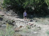
Coppertone hikes near the trailhead over a bridge first constructed by the Civilian Conservation Corps in the 1930's.
You will not find this hike on the official park map or any park literature
that we've come across. When stopping by the visitor center to view the exhibits and take in the
view from the rim of the canyon we were intrigued by a small yellow sign that indicated this was
the trailhead of the Triassic Trail.
It seemed to indicate that it was open to the public, but was it really? When we asked visitor
center volunteers they had no clue the trail even existed. A park ranger at the park entrance finally
had an answer for us. The old trail was indeed open, though reclamation work remained to be done.
The trail was apparently built at the time of some of the original Civilian Conservation Corps work
in the 1930's. The trail had been abandoned for years, but was now receiving the
attention it deserved.
We knew the trail was open, but where did it go? The park ranger described the route he remembered
and we believed we knew where it had to end up. Seemingly, this would not turn out to be that long
of a hike, so we planned on tackling it after doing the Lighthouse Trail. We were in for a surprise.
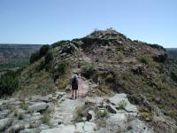
The Triassic Trail provides some of the only canyon top hiking in the park. Here Coppertone traverses a ridge between peaks.
Our hike begins at the waypoint "Trailhead". The path heads north and follows the contour of the
canyon rim. The trail surface is rocky with packed dirt. Unlike hikes on the canyon floor, Triassic
does not have lots of sandy patches. Several CCC trail features dot the trail including small
stone bridges that traverse stream beds along the way.
After the trail turns to the east it begins to descend in altitude until it reaches a ridge
leading to Goodnight Peak to the south. Once on the ridge we reach a fork in the trail. The path
to the left leads to a small parking area in a bend of the main park road. This is the trail
terminus that we expected based on the park ranger's description. But where did the other trail lead
to?
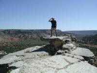
The Table Rock formation on the turnaround point. The rock sits on a promontory point and has spectacular views. The high winds required a wide stance.
Not content to leave that question unanswered we ventured off and followed the ridge line south.
By now the trail skirted the eastern edge of the ridge and overlooked the main park road as it
descended to the canyon floor below. Cars straining to climb or braking on the way down drove by.
A couple came to a complete stop. Were they taking in the view? It didn't seem like the spots where
they stopped provided a canyon view, but they did provide a glimpse of US. I think they actually
wondered what people were doing all of the way up there.
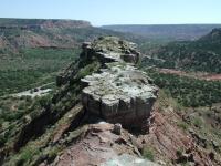
The Table Rock is not at the end of the ridge, but it is at the end of the hikable ridge. Down below to the left are horse stables that used to host a miniature railroad from the 1950's to the 1990's.
The ridge narrows quite a bit sometimes to a width not substantially wider than the trail itself.
Here the hiker is afforded spectacular views of the canyon both to the east and the west. Unlike
all of the other hikes in the park, this is the only one at the canyon's rim and provides unique
views of the canyon from above and not below the rim.
As the ridge begins to widen a bit another fork in the trail appears. What now? We've already
been surprised by what we'd found and weren't about to let our curiosity go unfulfilled. We took
the fork on the right and continued on the ridge to the south. The ridge widened and flattened.
Rock gave way to grasses and brush. The trail became a bit overgrown and we expected the trail to
peter out any moment.
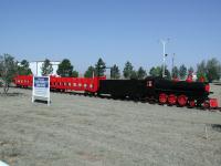
You can actually see the miniature railcars in the front yard of the family that used to run the operation in the park. This located just a couple of miles from the park. Liability insurance rates shut it down.
Just when we thought we had exhausted our interest in this portion of the trail we came upon end of
the line. We reached the southern-most limit of the ridge and came upon a rock promontory jutting
out into seemingly mid air. On this point stood a natural table rock. A single piece of rock with
a single support stuck right at the edge of the promontory like it was placed there for a reason.
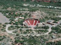
A different kind of view of the Texas amphitheater on the canyon floor.
It's not exactly dangerous to get the table, but the rock walkway leading to it is narrow. It's
narrow enough that you lose your peripheral vision's connection with the mountain beneath you.
For some with a bit of vertigo, such as my wife, that was a little too much to handle.
The view from the point is spectacular. Just to the east, a few hundred feet below lies the
amphitheater where the musical "Texas" had entertained park visitors for years. To the southeast,
the park's riding stables could be seen. To the west, Timber Creek. To the east, the Prairie
Dog Fork of the Red River. I could have stayed there for hours.
There's a small deteriorating shed near the table rock. Wiring laying about the structure and its
placement on the ridge above the amphitheater led us to believe that it may have played some
part in play productions in the past. We completed the small loop at the southern end of the ridge
and doubled back to the fork in the trail. Since we'd had good luck so far we decided to follow
the other trail as far as it would take us.
-small.jpg)
Coppertone was denied the opportunity to climb this very hill from the amphitheater as a child. She got to this time around!
The trail descends the slope of the ridge and then snakes through several monstrous switchbacks
headed downhill. Some portions of the trail had been reinforced with logs and pylons, so we knew
we were not off trail. However, the trail had several rock slides that had covered the trail for
short distances. We'd come up to a rock slide, think we'd done all we could, and then spot the
continuation of the trail on the other side of the slide. We climbed over and kept going.
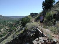
Coppertone hikes up the switchbacks from the canyon floor. Eventually we hike back all of the way to the information center at the canyon rim.
The trail finally ended in the parking lot of the amphitheater at the bottom of the canyon. At the
base of the mountain Coppertone had a memory flashback. When visiting the park as a child she had
wanted to climb this very mountain before a performance in the amphitheater and her parents would
not let her. After all of these years she had finally done it.
We had hiked all of the way from the top to the bottom of Palo Duro. What now? Hitch a ride back
to the visitor center? No way. We turned around and hiked back up the switchbacks to the top of
the ridge and retraced our steps to the trailhead.
This trail was by far our favorite in Palo Duro, from a pure hiking perspective. The sense of
mystery surrounding the trail and the high vistas it afforded put a great cap on our Palo Duro
trip. In three hours of hiking over four miles we didn't see another person on the trail. We had
it all to ourselves.